IMAGES TAKEN NEAR TO
Church Road, SALTASH, PL12 4HX
Introduction
This page details the photographs taken nearby to Church Road, PL12 4HX by members of the Geograph project.
The Geograph project started in 2005 with the aim of publishing, organising and preserving representative images for every square kilometre of Great Britain, Ireland and the Isle of Man.

There are currently over 7.5m images from over14,400 individuals and you can help contribute to the project by visiting https://www.geograph.org.uk
Image Map (Loading...)


Getting Data...Please wait
Leaflet Map data © OpenStreetMap
Images are licensed for reuse under creativecommons.org/licenses/by-sa/2.0
Notes
- Clicking on the map will re-center to the selected point.
- The higher the marker number, the further away the image location is from the centre of the postcode.
Image Listing (62 Images Found)
Images are licensed for reuse under creativecommons.org/licenses/by-sa/2.0
Image
Details
Distance
2
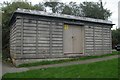
Electricity sub station, Alamein Road, Saltash
Pre-cast concrete electricity sub station, Alamein Road, Saltash.
Image: © Kevin Hale
Taken: 17 Oct 2005
0.10 miles
3
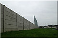
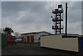
Western wall of Kimberley Stadium
The western wall of Kimberley Football Stadium, Saltash, Cornwall. The wall around the whole stadium has been replaced within the last couple of years.
Image: © Kevin Hale
Taken: 25 Dec 2008
0.11 miles