IMAGES TAKEN NEAR TO
Brooke Close, SALTASH, PL12 4EN
Introduction
This page details the photographs taken nearby to Brooke Close, PL12 4EN by members of the Geograph project.
The Geograph project started in 2005 with the aim of publishing, organising and preserving representative images for every square kilometre of Great Britain, Ireland and the Isle of Man.

There are currently over 7.5m images from over14,400 individuals and you can help contribute to the project by visiting https://www.geograph.org.uk
Image Map (Loading...)


Getting Data...Please wait
Leaflet Map data © OpenStreetMap
Images are licensed for reuse under creativecommons.org/licenses/by-sa/2.0
Notes
- Clicking on the map will re-center to the selected point.
- The higher the marker number, the further away the image location is from the centre of the postcode.
Image Listing (539 Images Found)
Images are licensed for reuse under creativecommons.org/licenses/by-sa/2.0
Image
Details
Distance

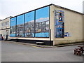
6
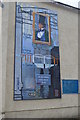
IKB Mural
The engineer for the famous Royal Albert Bridge.
Image: © John M
Taken: 13 Sep 2014
0.01 miles
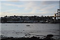
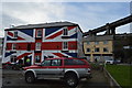
7
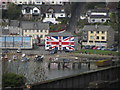
The Union Inn at Saltash
Looking across the River Tamar to the inn with its colourful and patriotic front.
Image: © Gareth James
Taken: 26 Apr 2015
0.01 miles
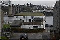
8
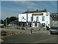
The Waterside public house, Saltash
The Waterside public house, Saltash, Cornwall, previously known as The Wheatsheaf. This view is looking from the Town Quay.
Image: © Kevin Hale
Taken: 11 Sep 2002
0.01 miles
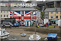
9
Livewire Youth Project building on Saltash waterfront
This plain concrete box of a building has been brightened up with murals by local artist Jim Thompson.
Image: © Rod Allday
Taken: 7 Feb 2010
0.02 miles