IMAGES TAKEN NEAR TO
Rendle Street, PLYMOUTH, PL1 1TP
Introduction
This page details the photographs taken nearby to Rendle Street, PL1 1TP by members of the Geograph project.
The Geograph project started in 2005 with the aim of publishing, organising and preserving representative images for every square kilometre of Great Britain, Ireland and the Isle of Man.

There are currently over 7.5m images from over14,400 individuals and you can help contribute to the project by visiting https://www.geograph.org.uk
Image Map (Loading...)


Getting Data...Please wait
Leaflet Map data © OpenStreetMap
Images are licensed for reuse under creativecommons.org/licenses/by-sa/2.0
Notes
- Clicking on the map will re-center to the selected point.
- The higher the marker number, the further away the image location is from the centre of the postcode.
Image Listing (500 Images Found)
Images are licensed for reuse under creativecommons.org/licenses/by-sa/2.0
Image
Details
Distance
1
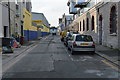
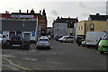
Manor Street, Plymouth
North along Manor Street from the corner of Union Street.
Image: © Jaggery
Taken: 14 Jul 2018
0.03 miles
3
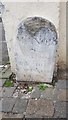
Old Boundary Marker
Parish Boundary Marker against a wall at the west end of Manor Gardens. PLYMOUTH parish. Inscribed MANOR / OF / STONEHOUSE / 26F 101 / EASTWARD.
Milestone Society National ID: DV_MOS02pb
Image: © C Mayne
Taken: 15 Sep 2019
0.05 miles