IMAGES TAKEN NEAR TO
Hessenford Road, TORPOINT, PL11 3JL
Introduction
This page details the photographs taken nearby to Hessenford Road, PL11 3JL by members of the Geograph project.
The Geograph project started in 2005 with the aim of publishing, organising and preserving representative images for every square kilometre of Great Britain, Ireland and the Isle of Man.

There are currently over 7.5m images from over14,400 individuals and you can help contribute to the project by visiting https://www.geograph.org.uk
Image Map
Images are licensed for reuse under creativecommons.org/licenses/by-sa/2.0
Notes
- Clicking on the map will re-center to the selected point.
- The higher the marker number, the further away the image location is from the centre of the postcode.
Image Listing (45 Images Found)
Images are licensed for reuse under creativecommons.org/licenses/by-sa/2.0
Image
Details
Distance
1
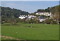
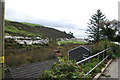
Seaton Park
Housing at the north end of the village, looking up the valley of the River Seaton, with a couple of water features on the green in the foreground. The houses are on either side of Seaton Park, a cul-de-sac off Tregunnick Lane.
Image: © Derek Harper
Taken: 2 Oct 2011
0.06 miles
3

The River Seaton
Taken from Seaton Bridge looking upstream.
Image: © jeff collins
Taken: 4 Dec 2013
0.09 miles
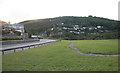
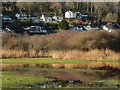
4
Green at Seaton
Like Image, a view across a pond and a sheet of water, from near Seaton Bridge across the River Seaton, which runs just to the left. To the right behind the houses on Seaton Park is the hillside shown in Image; to the left is an unnamed wood on the western slopes of the valley.
Image: © Derek Harper
Taken: 2 Oct 2011
0.09 miles
5
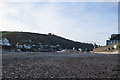
Seaton Beach
Looking inland towards the western side of the village.
Image: © Trevor Harris
Taken: 4 Apr 2017
0.09 miles
6
Looking over Seaton
From the small lane serving the houses high up on the hillside.
Image: © jeff collins
Taken: 4 Dec 2013
0.09 miles
7
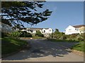
Mount Brioni, Seaton
"Mediterranean-style self-catering apartments", according to various websites. Seen here the from South West Coast Path climbing Looe Hill.
Image: © Derek Harper
Taken: 2 Oct 2011
0.10 miles
8
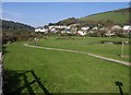
Seaton
Just north of the beach car park is this open space beside the River Seaton, with a small pool. In the background houses climb up the valley side.
Image: © Stephen McKay
Taken: 26 Dec 2016
0.11 miles
9
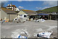
Storm damage
The Seaton Beach Cafe undergoing repair after the storm damage of 2014.
Image: © Robert Ashby
Taken: 18 Apr 2014
0.11 miles
10
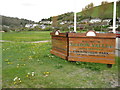
Seaton Valley
Sign for a holiday countryside park in Seaton valley.
Image: © Philip Halling
Taken: 16 Apr 2011
0.11 miles