IMAGES TAKEN NEAR TO
Kimberley Foster Close, TORPOINT, PL11 3DD
Introduction
This page details the photographs taken nearby to Kimberley Foster Close, PL11 3DD by members of the Geograph project.
The Geograph project started in 2005 with the aim of publishing, organising and preserving representative images for every square kilometre of Great Britain, Ireland and the Isle of Man.

There are currently over 7.5m images from over14,400 individuals and you can help contribute to the project by visiting https://www.geograph.org.uk
Image Map (Loading...)


Getting Data...Please wait
Leaflet Map data © OpenStreetMap
Images are licensed for reuse under creativecommons.org/licenses/by-sa/2.0
Notes
- Clicking on the map will re-center to the selected point.
- The higher the marker number, the further away the image location is from the centre of the postcode.
Image Listing (18 Images Found)
Images are licensed for reuse under creativecommons.org/licenses/by-sa/2.0
Image
Details
Distance
1
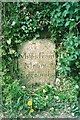
Old Milestone by the B3247, Crafthole
Carved stone post by the B3247, in parish of SHEVIOCK (CARADON District), Crafthole village, against wall, on West side of road. Edgcumbe gravestone, erected by a private estate in the 19th century.
Inscription reads:-
7
Miles From
Mount
Edgcumbe
Grade II Listed. List Entry Number: 1329139
https://historicengland.org.uk/listing/the-list/list-entry/1329139
Milestone Society National ID: CW_ME07.
Image: © Ian Thompson
Taken: 1 Apr 2003
0.05 miles
2
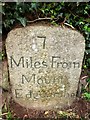
Old Milestone by the B3247, Crafthole
Carved stone post by the B3247, in parish of SHEVIOCK (CARADON District), Crafthole village, against wall, on West side of road. Edgcumbe gravestone, erected by a private estate in the 19th century.
Inscription reads:-
7
Miles From
Mount
Edgcumbe
Grade II listed.
List Entry Number: 1329139 https://historicengland.org.uk/listing/the-list/list-entry/1329139
Milestone Society National ID: CW_ME07.
Image: © Rosy Hanns
Taken: 14 Apr 2019
0.05 miles
3
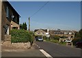
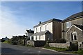
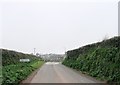
Junction at Crafthole
See Image; with the bus out of the way, more buildings can be seen.
Image: © Derek Harper
Taken: 2 Oct 2011
0.07 miles
4
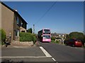
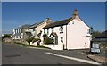
Bus at Crafthole
The pink livery of an 81C from Plymouth to Cremyll passes along the B3247 at the junction with West Lane (left) and Sheviock Lane (right - the old fork, blocked to traffic).
Image: © Derek Harper
Taken: 2 Oct 2011
0.07 miles
7
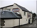
Houses at Crafthole
Taken at the junction of the B3247 with West Lane (right) and Finnygook Lane.
Image: © Derek Harper
Taken: 2 Oct 2011
0.12 miles
8
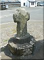
Old Wayside Cross by the B3247, Crafthole, Sheviock parish
Crafthole Cross, old head and neck, Langdon EC No. 86 by the B3247, in parish of Sheviock (Caradon District), Crafthole crossroads, nearly opposite Finnygook Inn, set on paving by boundary bank of Whitesands Golf Course.
Scheduled Monument.
List Entry Number: 1010857 https://historicengland.org.uk/listing/the-list/list-entry/1010857
Surveyed
Milestone Society National ID: CWCN_SHE01
Image: © Alan Rosevear
Taken: 22 May 2012
0.13 miles
10
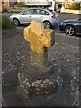
Wayside Cross at Crafthole
At the crossroads from which Image was taken.
Image: © Derek Harper
Taken: 2 Oct 2011
0.13 miles