IMAGES TAKEN NEAR TO
Sydney Road, TORPOINT, PL11 2LZ
Introduction
This page details the photographs taken nearby to Sydney Road, PL11 2LZ by members of the Geograph project.
The Geograph project started in 2005 with the aim of publishing, organising and preserving representative images for every square kilometre of Great Britain, Ireland and the Isle of Man.

There are currently over 7.5m images from over14,400 individuals and you can help contribute to the project by visiting https://www.geograph.org.uk
Image Map (Loading...)


Getting Data...Please wait
Leaflet Map data © OpenStreetMap
Images are licensed for reuse under creativecommons.org/licenses/by-sa/2.0
Notes
- Clicking on the map will re-center to the selected point.
- The higher the marker number, the further away the image location is from the centre of the postcode.
Image Listing (27 Images Found)
Images are licensed for reuse under creativecommons.org/licenses/by-sa/2.0
Image
Details
Distance
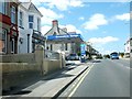
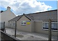
4
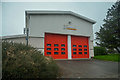
Torpoint Fire Station
Torpoint Fire Station, Antony Road, Torpoint, Cornwall, built to replace the fire station in Fore Street (see Image).
Image: © Kevin Hale
Taken: 26 Sep 2004
0.10 miles
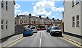
7
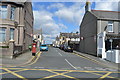
Torpoint : York Road
York Road at the junction with Anthony Road with Torporint Computers in view.
Image: © Lewis Clarke
Taken: 8 Apr 2015
0.12 miles
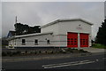
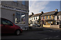
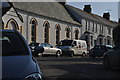
9
Torpoint : Fire Station
Looking towards the fire station on Antony Road.
Image: © Lewis Clarke
Taken: 17 Mar 2020
0.13 miles
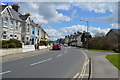
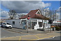
10
Torpoint : Buller Road
Looking along Buller Road in Torpoint.
Image: © Lewis Clarke
Taken: 8 Apr 2015
0.13 miles