IMAGES TAKEN NEAR TO
Trematon Close, TORPOINT, PL11 2JG
Introduction
This page details the photographs taken nearby to Trematon Close, PL11 2JG by members of the Geograph project.
The Geograph project started in 2005 with the aim of publishing, organising and preserving representative images for every square kilometre of Great Britain, Ireland and the Isle of Man.

There are currently over 7.5m images from over14,400 individuals and you can help contribute to the project by visiting https://www.geograph.org.uk
Image Map
Images are licensed for reuse under creativecommons.org/licenses/by-sa/2.0
Notes
- Clicking on the map will re-center to the selected point.
- The higher the marker number, the further away the image location is from the centre of the postcode.
Image Listing (30 Images Found)
Images are licensed for reuse under creativecommons.org/licenses/by-sa/2.0
Image
Details
Distance
1
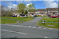
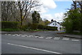
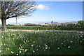
By Trevithick Avenue, Torpoint
On the left is Penlee Park. Public footpath 639 2/1 runs along the path in the foreground.
Image: © Derek Harper
Taken: 19 May 2018
0.06 miles
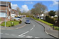
7
View from the gateway of Antony House
Looking across the A374 to Torpoint and beyond.
Image: © Trevor Harris
Taken: 4 Apr 2017
0.13 miles
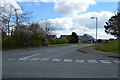
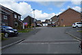
8
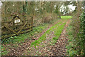
Field entrance off Goad Avenue
Private, as you can see.
Image: © Derek Harper
Taken: 2 Mar 2019
0.15 miles