IMAGES TAKEN NEAR TO
The Triangle, TORPOINT, PL10 1PJ
Introduction
This page details the photographs taken nearby to The Triangle, PL10 1PJ by members of the Geograph project.
The Geograph project started in 2005 with the aim of publishing, organising and preserving representative images for every square kilometre of Great Britain, Ireland and the Isle of Man.

There are currently over 7.5m images from over14,400 individuals and you can help contribute to the project by visiting https://www.geograph.org.uk
Image Map (Loading...)


Getting Data...Please wait
Leaflet Map data © OpenStreetMap
Images are licensed for reuse under creativecommons.org/licenses/by-sa/2.0
Notes
- Clicking on the map will re-center to the selected point.
- The higher the marker number, the further away the image location is from the centre of the postcode.
Image Listing (201 Images Found)
Images are licensed for reuse under creativecommons.org/licenses/by-sa/2.0
Image
Details
Distance
1
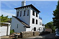
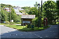
Penlee Lodge
Grade II listed. https://www.britishlistedbuildings.co.uk/101160387-penlee-lodge-maker-with-rame
Image: © N Chadwick
Taken: 1 Jun 2017
0.00 miles
2
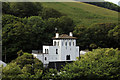
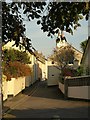
Penlee Lodge, St Andrew's Place, from New Road, Cawsand
Grade II Listed gatehouse for Mount Edgcumbe Estate around 1860. Built on basement storey of Napoleonic fortification, with addition of late 20th century and alterations. In the 1861 census a Richard Buttons is listed at 34 Church Road, Italian Cottage, possibly now the Penlee Lodge. The 1911 census list Thomas Pearse a woodranger at the Mt Edgcumbe Estate the head of the house with wife, daughter and son. Reminisces of a lady born in 1916 includes 'There was always a game keeper that use to live in Penlee Lodge He was a Very kind man, a Mr Hawke by name and every Christmas he used to cut us a splendid tree from the woods for us all to enjoy. I remember Mum sending us all up to thank him and take him up a large packet of Players Cigarettes, they cost 11 ½ in those days.' (11.1/2d = 4.1/2p).
Image: © Jo and Steve Turner
Taken: 25 Jun 2019
0.01 miles
6
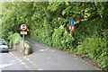
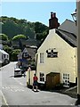
Armada Road, Cawsand
Looking down the street from the village car park.
Image: © Derek Harper
Taken: 1 Oct 2011
0.06 miles
8
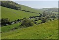
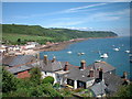
Valley and road
Cars parked on the valley road.
Image: © Jay Pea
Taken: 7 May 2018
0.07 miles
9
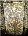
Old Boundary Marker
War Department Boundary Marker set into the wall on the south side of New Road, Cawsand. MAKER WITH RAME parish. Inscribed W ↑ D / No 13. The marker is on the boundary of the former Cawsand Fort.
Milestone Society National ID: CW_WDCAW13Aem
Image: © R Hanns
Taken: 27 Oct 2019
0.07 miles
10
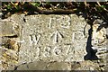
Old Boundary Marker
War Department Boundary Marker situated high on the south facing wall on the south side of St Andrews Street, Cawsand. MAKER WITH RAME parish. Inscribed 13 / W ↑ D / 1867. The marker is on the boundary of the former Cawsand Fort.
Milestone Society National ID: CW_WDCAW13Bem
Image: © R Hanns
Taken: 27 Oct 2019
0.07 miles