IMAGES TAKEN NEAR TO
Kingsway, TORPOINT, PL10 1NG
Introduction
This page details the photographs taken nearby to Kingsway, PL10 1NG by members of the Geograph project.
The Geograph project started in 2005 with the aim of publishing, organising and preserving representative images for every square kilometre of Great Britain, Ireland and the Isle of Man.

There are currently over 7.5m images from over14,400 individuals and you can help contribute to the project by visiting https://www.geograph.org.uk
Image Map (Loading...)


Getting Data...Please wait
Leaflet Map data © OpenStreetMap
Images are licensed for reuse under creativecommons.org/licenses/by-sa/2.0
Notes
- Clicking on the map will re-center to the selected point.
- The higher the marker number, the further away the image location is from the centre of the postcode.
Image Listing (195 Images Found)
Images are licensed for reuse under creativecommons.org/licenses/by-sa/2.0
Image
Details
Distance
2
Pilchard salting shed Cawsand
Old fisherman's store where Pilchards and Herring were salted and boats stored.
Image: © Darren Rosson
Taken: 5 Feb 2007
0.01 miles
3
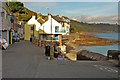
Kingsand: House along the Seafront
Image: © Mr Eugene Birchall
Taken: 13 Oct 2009
0.02 miles
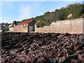
4
Maker with Rame: pilchard cellar near Kingsand
Now used as a store this is one of the last survivors of a series of fish cellars dating back to the late 16th century, built to bypass middlemen in Plymouth. Most of the cellars have decayed and are no more than ruined walls. Beyond is a housing development at Picklecombe Point, converted from a semi-circular fort [Source: Liz Luck. South Cornish Harbours. Nautical Books, 1988]
Image: © Martin Bodman
Taken: 18 Jul 2007
0.02 miles
5
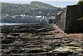
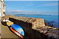
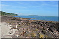
Kingsand Foreshore
The end of the village, only rocks on the foreshore, but there are several interesting rock pools amongst them.
Image: © Jay Pea
Taken: 7 May 2018
0.03 miles
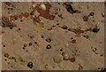
7
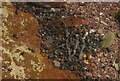
Kingsand Rock Pool
One of many rock pools along the foreshore.
Image: © Jay Pea
Taken: 7 May 2018
0.03 miles
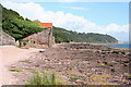
8
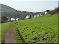
Minadew Brakes pathway
A view back towards the village of Kingsand from the pathway that leads from that village to Mount Edgcumbe.
Image: © Rob Farrow
Taken: 25 Jan 2014
0.04 miles
10
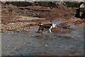
Investigation
A Collie Dog investigating the smells.
Image: © Jay Pea
Taken: 7 May 2018
0.04 miles