IMAGES TAKEN NEAR TO
Rame, TORPOINT, PL10 1LG
Introduction
This page details the photographs taken nearby to PL10 1LG by members of the Geograph project.
The Geograph project started in 2005 with the aim of publishing, organising and preserving representative images for every square kilometre of Great Britain, Ireland and the Isle of Man.

There are currently over 7.5m images from over14,400 individuals and you can help contribute to the project by visiting https://www.geograph.org.uk
Image Map (Loading...)


Getting Data...Please wait
Leaflet Map data © OpenStreetMap
Images are licensed for reuse under creativecommons.org/licenses/by-sa/2.0
Notes
- Clicking on the map will re-center to the selected point.
- The higher the marker number, the further away the image location is from the centre of the postcode.
Image Listing (65 Images Found)
Images are licensed for reuse under creativecommons.org/licenses/by-sa/2.0
Image
Details
Distance
3
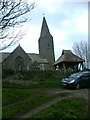
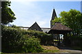
St Germanus, Rame
The front of St Germanus, parts of this candlit church date from 1259.
Image: © John Poyser
Taken: 11 Feb 2007
0.06 miles
4
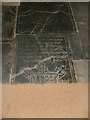
Stone floor
The headstones in the aisle at St Germanus.
Image: © John Poyser
Taken: 11 Feb 2007
0.06 miles
7
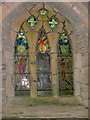
Stained Glass Window
The side window at St Germanus.
Image: © John Poyser
Taken: 11 Feb 2007
0.07 miles
8

16th.century pew
One of the oldest parts of the church.
Image: © John Poyser
Taken: 11 Feb 2007
0.07 miles
10
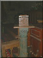
Collection box
Collection box inside St Germanus.
Image: © John Poyser
Taken: 11 Feb 2007
0.07 miles