IMAGES TAKEN NEAR TO
Tregonhawke, Millbrook, TORPOINT, PL10 1JU
Introduction
This page details the photographs taken nearby to PL10 1JU by members of the Geograph project.
The Geograph project started in 2005 with the aim of publishing, organising and preserving representative images for every square kilometre of Great Britain, Ireland and the Isle of Man.

There are currently over 7.5m images from over14,400 individuals and you can help contribute to the project by visiting https://www.geograph.org.uk
Image Map (Loading...)


Getting Data...Please wait
Leaflet Map data © OpenStreetMap
Images are licensed for reuse under creativecommons.org/licenses/by-sa/2.0
Notes
- Clicking on the map will re-center to the selected point.
- The higher the marker number, the further away the image location is from the centre of the postcode.
Image Listing (18 Images Found)
Images are licensed for reuse under creativecommons.org/licenses/by-sa/2.0
Image
Details
Distance
1
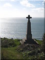
Memorial on the cliff top at Whitesand Bay
The inscription reads: 'To the beloved memory of Edward Spender aged 44 years and of his sons, Reginald, aged 13 years and Sidney, aged 11 years, who were drowned whilst bathing beneath this cliff on Whit Sunday, June 9 1878'. The plaque on the other side records that Mr Spender was one of the founders of the Plymouth-based Western Morning News.
Image: © Rod Allday
Taken: 26 Feb 2011
0.01 miles
2
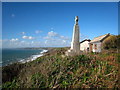
Memorial on the cliff at Whitesand Bay
Another view of the memorial, for details see Image
Image: © Rod Allday
Taken: 26 Feb 2011
0.01 miles
3
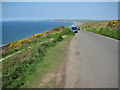
Military Road at Tregonhawke
View to the west along the coast from the Military Road at Tregonhawke.
Image: © Philip Halling
Taken: 17 Apr 2011
0.01 miles
4
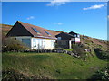
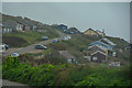
Bungalows by the Military Road at Whitesand Bay
These are more elaborate than the chalets originally constructed in the area Image
Image: © Rod Allday
Taken: 26 Feb 2011
0.03 miles
5
Chalets above the beach at Whitesand Bay
Quite humble structures compared with the ones on the cliff top Image
Image: © Rod Allday
Taken: 26 Feb 2011
0.05 miles
6
St John : Military Road
Looking along Military Road in the parish of St John.
Image: © Lewis Clarke
Taken: 17 Mar 2020
0.07 miles
7
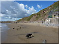
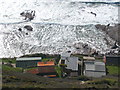
On the beach at Tregonhawke
Beside a small surf-school building, Daft Dog gets wet in the waves again.
Image: © Richard Law
Taken: 9 Oct 2016
0.10 miles
8
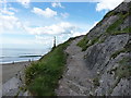
Pathway down to the beach
A narrow (sometimes steep) path that descends the cliff from roadside parking at Tregonhawke. This is looking back up the last section, just before it drops down onto the sometimes tidewashed rocks.
Image: © Richard Law
Taken: 9 Oct 2016
0.13 miles
9
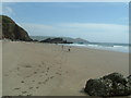
Whitsand Bay near Chamber Rock
Having revisited this beach I'm now happier to relocate it to the northwest. The rocks seen are those around Chamber Rock rather than Ninney Rocks as I first thought.
Image: © Rob Farrow
Taken: 24 Apr 2003
0.13 miles
10
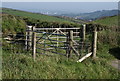
Gates near Tregonhawke
A pair of gates give field access beside the coast road west of Tregonhawke. The valley behind gives a glimpse of Plymouth.
Image: © Derek Harper
Taken: 1 Oct 2011
0.13 miles