IMAGES TAKEN NEAR TO
Millbrook, TORPOINT, PL10 1JJ
Introduction
This page details the photographs taken nearby to PL10 1JJ by members of the Geograph project.
The Geograph project started in 2005 with the aim of publishing, organising and preserving representative images for every square kilometre of Great Britain, Ireland and the Isle of Man.

There are currently over 7.5m images from over14,400 individuals and you can help contribute to the project by visiting https://www.geograph.org.uk
Image Map (12 Images)


Getting Data...Please wait
Leaflet Map data © OpenStreetMap
Images are licensed for reuse under creativecommons.org/licenses/by-sa/2.0
Notes
- Clicking on the map will re-center to the selected point.
- The higher the marker number, the further away the image location is from the centre of the postcode.
Image Listing (12 Images Found)
Images are licensed for reuse under creativecommons.org/licenses/by-sa/2.0
Image
Details
Distance
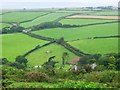
1
Withnoe Barton
The farmhouse, towards the right, dates back to the C17 http://www.britishlistedbuildings.co.uk/en-61934-withnoe-barton-st-john .
Image: © Derek Harper
Taken: 1 Oct 2011
0.03 miles
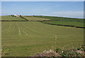
2
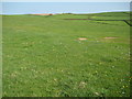
Farmland at Freathy
Farmland at Freathy viewed from the Military Road.
Image: © Philip Halling
Taken: 17 Apr 2011
0.12 miles
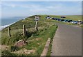
3
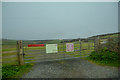
St John : Car Park
A closed car park off Military Road.
Image: © Lewis Clarke
Taken: 17 Mar 2020
0.16 miles
4
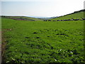
Cattle near Tregonhawke
Cattle grazing in a field near Tregonhawke.
Image: © Philip Halling
Taken: 17 Apr 2011
0.17 miles
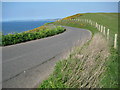
5
Coast road near Withnoe
The coast path follows the road here. Plenty of takers for the car park in a field at £3 all day.
Image: © Derek Harper
Taken: 1 Oct 2011
0.18 miles
6
Farmland at Freathy
Looking across fields northeast of the settlement, with outlying chalets near Freathy Bungalow on the left.
Image: © Derek Harper
Taken: 1 Oct 2011
0.20 miles
7
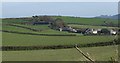
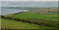
Rame peninsula, looking north from Whitesand Bay Battery
Stone Farm in the foreground.
Image: © Penny Mayes
Taken: 17 Jul 2004
0.20 miles
8
Military Road near Treathy
Military Road above Whitsand Bay near Treathy.
Image: © Philip Halling
Taken: 17 Apr 2011
0.21 miles
9
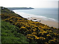
North west along the coast towards Portwrinkle & Downderry
From Whitesands Battery. The odd black and white line across the lower half of the picture are cattle eating their way across a kale field.
Image: © Penny Mayes
Taken: 17 Jul 2004
0.23 miles
10
View to Rame Head
View to Rame Head from the Military Road to the south of Freathy.
Image: © Philip Halling
Taken: 17 Apr 2011
0.24 miles