IMAGES TAKEN NEAR TO
Millbrook, TORPOINT, PL10 1JD
Introduction
This page details the photographs taken nearby to PL10 1JD by members of the Geograph project.
The Geograph project started in 2005 with the aim of publishing, organising and preserving representative images for every square kilometre of Great Britain, Ireland and the Isle of Man.

There are currently over 7.5m images from over14,400 individuals and you can help contribute to the project by visiting https://www.geograph.org.uk
Image Map (7 Images)


Getting Data...Please wait
Leaflet Map data © OpenStreetMap
Images are licensed for reuse under creativecommons.org/licenses/by-sa/2.0
Notes
- Clicking on the map will re-center to the selected point.
- The higher the marker number, the further away the image location is from the centre of the postcode.
Image Listing (7 Images Found)
Images are licensed for reuse under creativecommons.org/licenses/by-sa/2.0
Image
Details
Distance
1
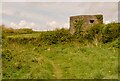
Military Pillbox
A disused military pillbox used during World War 2.
Image: © Jay Pea
Taken: 1 May 2018
0.11 miles
2
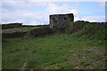
Defending Wiggle
This pillbox near Wiggle and (ironically) Peacehaven is actually part of the WWII defensive system around Plymouth.
Image: © Trevor Harris
Taken: 1 Apr 2017
0.13 miles
3

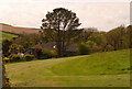
Bluebells
The woodland opposite Wringford Farmhouse.
Image: © Jay Pea
Taken: 9 May 2018
0.20 miles
4
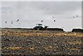
Ploughing
The field has just started to be ploughed.
Image: © Jay Pea
Taken: 6 May 2018
0.21 miles
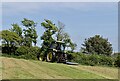
7
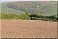
Ploughed Field
The footpath crossing the recently ploughed field.
Image: © Jay Pea
Taken: 7 May 2018
0.25 miles