IMAGES TAKEN NEAR TO
Lower Anderton Road, TORPOINT, PL10 1HW
Introduction
This page details the photographs taken nearby to Lower Anderton Road, PL10 1HW by members of the Geograph project.
The Geograph project started in 2005 with the aim of publishing, organising and preserving representative images for every square kilometre of Great Britain, Ireland and the Isle of Man.

There are currently over 7.5m images from over14,400 individuals and you can help contribute to the project by visiting https://www.geograph.org.uk
Image Map (Loading...)


Getting Data...Please wait
Leaflet Map data © OpenStreetMap
Images are licensed for reuse under creativecommons.org/licenses/by-sa/2.0
Notes
- Clicking on the map will re-center to the selected point.
- The higher the marker number, the further away the image location is from the centre of the postcode.
Image Listing (13 Images Found)
Images are licensed for reuse under creativecommons.org/licenses/by-sa/2.0
Image
Details
Distance
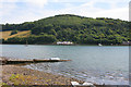
1
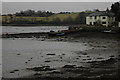
House overlooking Millbrook Lake
House overlooking Millbrook Lake, part of the tamar estuary, at Low tide.
Image: © Philip Halling
Taken: 24 Feb 2009
0.06 miles
2
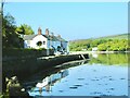
Row of cottage s
Lower Anderson Road and cottages.
Image: © Jay Pea
Taken: 6 May 2018
0.12 miles
3
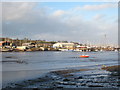
Millbrook Lake at low tide
Looking towards the boatyards at Southdown.
Image: © Rod Allday
Taken: 6 Dec 2009
0.13 miles
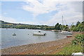
4
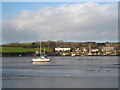
Millbrook Lake
Waterside houses at Southdown are across the water.
Image: © Rod Allday
Taken: 6 Dec 2009
0.14 miles
5
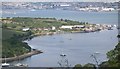
Southdown on the Insworke Peninsula
This photograph was taken from the viewpoint on Maker Heights at SX430515. It looks very pretty with the tide in but when the tide is out - which is most of the time - almost all the foreground water is mud flats. In the background is the River Tamar and Devonport Dockyard.
Image: © Tony Atkin
Taken: 12 Aug 2005
0.20 miles
6
Millbrook Lake
The next tidal lake on the Tamar estuary, south east of Image Weir Cottages straight ahead with Clarrick Wood behinds. This photograph was taken from the shore at the end of Silver Terrace just west of the Image
Image: © Kate Jewell
Taken: 18 Aug 2006
0.20 miles
7
Shoreline at Southdown near Millbrook
Millbrook Lake narrows at Foss Point, centre left, before widening out again as it approaches Millbrook.
Image: © Kate Jewell
Taken: 18 Aug 2006
0.20 miles
8
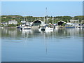
Boatyard and reflections
One of the many boatyards near to Millbrook.
Image: © Jay Pea
Taken: 6 May 2018
0.20 miles
9
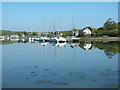
Boat yard and reflections 2
Another boat yard near Millbrook, again the mirror like finish and sunshine have created excellent reflections.
Image: © Jay Pea
Taken: 6 May 2018
0.20 miles
10
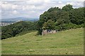
Old Fortification on Maker Heights
This redoubt, overgrown with trees sits on the inland side of the heights overlooking Millbrook Lake.
Image: © Tony Atkin
Taken: 12 Aug 2005
0.21 miles