IMAGES TAKEN NEAR TO
Mount Edgcumbe, TORPOINT, PL10 1HS
Introduction
This page details the photographs taken nearby to PL10 1HS by members of the Geograph project.
The Geograph project started in 2005 with the aim of publishing, organising and preserving representative images for every square kilometre of Great Britain, Ireland and the Isle of Man.

There are currently over 7.5m images from over14,400 individuals and you can help contribute to the project by visiting https://www.geograph.org.uk
Image Map (Loading...)


Getting Data...Please wait
Leaflet Map data © OpenStreetMap
Images are licensed for reuse under creativecommons.org/licenses/by-sa/2.0
Notes
- Clicking on the map will re-center to the selected point.
- The higher the marker number, the further away the image location is from the centre of the postcode.
Image Listing (20 Images Found)
Images are licensed for reuse under creativecommons.org/licenses/by-sa/2.0
Image
Details
Distance
1
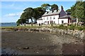
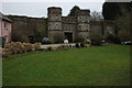
Empacombe House and Quay
A delightful spot where Millbrook Lake meets the Tamar estuary. Empacombe House is described at http://list.historicengland.org.uk/resultsingle.aspx?uid=1140664&searchtype=mapsearch . The quay is also listed, with "vertical stonework with bands of horizontal stonework" http://list.historicengland.org.uk/resultsingle.aspx?uid=1160588&searchtype=mapsearch . It is identified as C18.
Image: © Derek Harper
Taken: 8 Aug 2015
0.01 miles
2
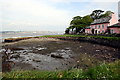
Empacombe Harbour
This little harbour near the entrance to Millbrook Lake is now unused and the harbourside covered in grass.
Image: © Tony Atkin
Taken: 5 May 2008
0.01 miles
3
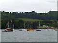
Yachts moored off Empacombe harbour
The wooded slopes drop to Millbrook Lake, the river estuary that flows into the Tamar
Image: © David Smith
Taken: 3 Jul 2013
0.03 miles
4
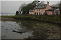
House overlooking Empacombe Harbour
The old harbour beside Millbrook Lake, part of the Tamar estuary is now unused.
Image: © Philip Halling
Taken: 24 Feb 2009
0.03 miles
5

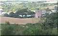
Home Farm Empacombe
Maker Church on the top
Image: © Darren Rosson
Taken: 30 Jun 2002
0.06 miles
6
Empacombe Harbour
Not sure of the origin of this castle-like building at Empacombe Harbour?
Image: © Philip Halling
Taken: 24 Feb 2009
0.06 miles
7
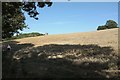
Empacombe Windmill
It's listed as "Empacombe Windmill", but the listed building description at http://list.historicengland.org.uk/resultsingle.aspx?uid=1140665&searchtype=mapsearch says "tower, original purpose unknown". Seen from footpath 617 37/2 across the same field as Image
Image: © Derek Harper
Taken: 8 Aug 2015
0.08 miles
8
Old windmill at Empacombe
This round tower is believed to be the remains of a windmill. In the background, across Millbrook Lake is Southdown.
Image: © Tony Atkin
Taken: 12 Aug 2005
0.13 miles
9
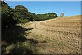
Stubble field near Empacombe
From footpath 617 37/2, with the top of Empacombe Windmill http://list.historicengland.org.uk/resultsingle.aspx?uid=1140665&searchtype=mapsearch visible ahead.
Image: © Derek Harper
Taken: 8 Aug 2015
0.14 miles
10
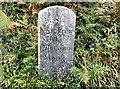
Old Milestone by the B3247, north of Mount Edgcumbe Farm
Carved stone post by the B3247, in parish of MAKER WITH RAME (CARADON District), Mount Edgcumbe Farm, above farm turning, on the grass bank verge, on East side of road. Edgcumbe gravestone, erected by a private estate in the 19th century.
Inscription reads:-
½
Mile From
Mot
Edgcumbe
House
Carved benchmark on front lower face.
Grade II Listed. List Entry Number: 1140667
https://historicengland.org.uk/listing/the-list/list-entry/1140667
Milestone Society National ID: CW_ME00.
Image: © Ian Thompson
Taken: 1 Nov 2001
0.19 miles