IMAGES TAKEN NEAR TO
Mill Road, TORPOINT, PL10 1EN
Introduction
This page details the photographs taken nearby to Mill Road, PL10 1EN by members of the Geograph project.
The Geograph project started in 2005 with the aim of publishing, organising and preserving representative images for every square kilometre of Great Britain, Ireland and the Isle of Man.

There are currently over 7.5m images from over14,400 individuals and you can help contribute to the project by visiting https://www.geograph.org.uk
Image Map (Loading...)


Getting Data...Please wait
Leaflet Map data © OpenStreetMap
Images are licensed for reuse under creativecommons.org/licenses/by-sa/2.0
Notes
- Clicking on the map will re-center to the selected point.
- The higher the marker number, the further away the image location is from the centre of the postcode.
Image Listing (25 Images Found)
Images are licensed for reuse under creativecommons.org/licenses/by-sa/2.0
Image
Details
Distance
1
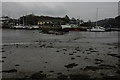
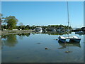
View to Foss
View to Foss at low tide from Foss Point.
Image: © Philip Halling
Taken: 24 Feb 2009
0.04 miles
2

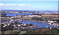
Foss & Anderton from Maker
Looking down on the Millbrook Creak as it weaves between Anderton (linked to Millbrook) on the left (west) and Foss, on the far side of the creak, ahead (north) with Millbrook Lake to the right (east). Taken from the junction of the B3247 and Image]
Image: © Rob Farrow
Taken: 28 Jul 2019
0.05 miles
3
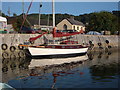
Fosse Quay - 'Coronette' just been launched
Maurice Griffiths design shallow draught yacht is ideal for navigating up drying estuaries such as Millbrook. There's not much drying that goes on here though as there's mud everywhere - including the metaphorical Millbrook mud that people like to try and wade through / get stuck in.
Image: © BB
Taken: 17 Jul 2006
0.05 miles
5
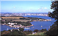
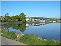
Southdown and Millbrook Lake from Cremyll road
Image: © Martin Southwood
Taken: 15 Aug 2002
0.07 miles
6

The view across the water from Foss point
Boats moored up across the water.
Image: © roger geach
Taken: 28 Nov 2012
0.10 miles
7

Low tide, Millbrook Lake
View at low tide from Foss pint to Millbrook Lake.
Image: © Philip Halling
Taken: 24 Feb 2009
0.11 miles
9
Millbrook Lake
Looking across the Lake towards Foss.
Image: © Jay Pea
Taken: 6 May 2018
0.13 miles
10

Millbrook Lake
Millbrook Lake is a tidal creek at the head of which is Millbrook village. At the upper end the lake has been dammed to form a non-tidal saline pond; this is the view just below the dam taken from Lower Anderton Road.
Image: © Stephen McKay
Taken: 1 Jan 2018
0.14 miles