IMAGES TAKEN NEAR TO
Grandtully, PITLOCHRY, PH9 0PU
Introduction
This page details the photographs taken nearby to PH9 0PU by members of the Geograph project.
The Geograph project started in 2005 with the aim of publishing, organising and preserving representative images for every square kilometre of Great Britain, Ireland and the Isle of Man.

There are currently over 7.5m images from over14,400 individuals and you can help contribute to the project by visiting https://www.geograph.org.uk
Image Map
Images are licensed for reuse under creativecommons.org/licenses/by-sa/2.0
Notes
- Clicking on the map will re-center to the selected point.
- The higher the marker number, the further away the image location is from the centre of the postcode.
Image Listing (15 Images Found)
Images are licensed for reuse under creativecommons.org/licenses/by-sa/2.0
Image
Details
Distance
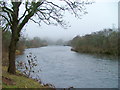
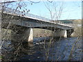
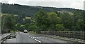
2
River Tay
View downstream from Pitnacree Bridge.
Image: © Richard Webb
Taken: 23 May 2012
0.09 miles
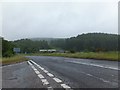
4
The River Tay
Looking northwest. The bridge carries the Aberfeldy to Ballinluig road.
Image: © Dave Fergusson
Taken: 27 Dec 2006
0.12 miles
6
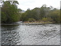
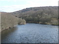
River Tay divides to flow round island
Floods change the riverbed and the islands are always changing. Some are more permanent than others.
Image: © Russel Wills
Taken: 20 Oct 2009
0.14 miles
7
Pitnacree Bridge over River Tay
Opened on 26 March 1976.
Image: © Russel Wills
Taken: 31 Mar 2009
0.14 miles
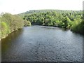
8
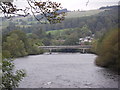
River Tay and Pitnacree Bridge
Looking upstream.
Image: © Peter Bond
Taken: 30 Sep 2011
0.14 miles
10
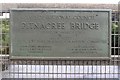
Opening Plaque, A827 Pitnacree Bridge
Image: © Graeme Yuill
Taken: 31 Jul 2019
0.14 miles