IMAGES TAKEN NEAR TO
Tulliemet, PITLOCHRY, PH9 0PB
Introduction
This page details the photographs taken nearby to PH9 0PB by members of the Geograph project.
The Geograph project started in 2005 with the aim of publishing, organising and preserving representative images for every square kilometre of Great Britain, Ireland and the Isle of Man.

There are currently over 7.5m images from over14,400 individuals and you can help contribute to the project by visiting https://www.geograph.org.uk
Image Map
Images are licensed for reuse under creativecommons.org/licenses/by-sa/2.0
Notes
- Clicking on the map will re-center to the selected point.
- The higher the marker number, the further away the image location is from the centre of the postcode.
Image Listing (8 Images Found)
Images are licensed for reuse under creativecommons.org/licenses/by-sa/2.0
Image
Details
Distance
1
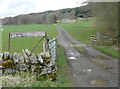
The track to Ballachraggan
Could do with a new sign.
Image: © Russel Wills
Taken: 10 Apr 2009
0.11 miles
4
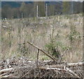
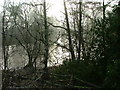
New growth
Young trees fighting to get clear of the debris of clear fell.
Image: © Russel Wills
Taken: 10 Apr 2009
0.19 miles
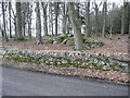
5
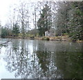
Pond at Tulliemet Lodge
Some ducks were swimming around the ice.
Image: © Russel Wills
Taken: 22 Dec 2008
0.19 miles
6
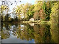
Pond among the Trees
Part of Tulliemet estate.
Image: © Dave Fergusson
Taken: 24 Dec 2006
0.21 miles
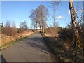
8
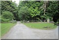
One of the entrance drives to Tulliemet House
The road on the right, part of which can be seen in the photograph, leads to Milton of Tulliemet.
Image: © James Denham
Taken: 22 Jul 2013
0.23 miles