IMAGES TAKEN NEAR TO
Tulliemet, PITLOCHRY, PH9 0PA
Introduction
This page details the photographs taken nearby to PH9 0PA by members of the Geograph project.
The Geograph project started in 2005 with the aim of publishing, organising and preserving representative images for every square kilometre of Great Britain, Ireland and the Isle of Man.

There are currently over 7.5m images from over14,400 individuals and you can help contribute to the project by visiting https://www.geograph.org.uk
Image Map
Images are licensed for reuse under creativecommons.org/licenses/by-sa/2.0
Notes
- Clicking on the map will re-center to the selected point.
- The higher the marker number, the further away the image location is from the centre of the postcode.
Image Listing (15 Images Found)
Images are licensed for reuse under creativecommons.org/licenses/by-sa/2.0
Image
Details
Distance

4

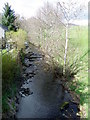
Butterbur, Tulliemet
Butterbur growing beside the minor road near Tulliemet. For a closer view Image
Image: © Maigheach-gheal
Taken: 12 Apr 2011
0.18 miles

6
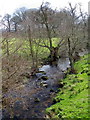
Butterbur (Petasites hybridus)
The male flower which is shown here is the more common and the flower heads can grow to a height of 40cm. The plant grows in wet places and it is here growing beside the Pantaskel Burn.
Image: © Maigheach-gheal
Taken: 12 Apr 2011
0.18 miles
7
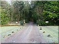
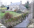
Driveway to Tulliemet House
Tulliemet, a large house and farm on the Atholl Estate.
Image: © Dave Fergusson
Taken: 24 Dec 2006
0.18 miles
8

Farm track to Balnafuaran and Drummin
Lined with Ash trees.
Image: © M J Richardson
Taken: 1 Feb 2019
0.19 miles