IMAGES TAKEN NEAR TO
Ballinluig, PITLOCHRY, PH9 0NS
Introduction
This page details the photographs taken nearby to PH9 0NS by members of the Geograph project.
The Geograph project started in 2005 with the aim of publishing, organising and preserving representative images for every square kilometre of Great Britain, Ireland and the Isle of Man.

There are currently over 7.5m images from over14,400 individuals and you can help contribute to the project by visiting https://www.geograph.org.uk
Image Map
Images are licensed for reuse under creativecommons.org/licenses/by-sa/2.0
Notes
- Clicking on the map will re-center to the selected point.
- The higher the marker number, the further away the image location is from the centre of the postcode.
Image Listing (17 Images Found)
Images are licensed for reuse under creativecommons.org/licenses/by-sa/2.0
Image
Details
Distance
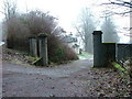
1

Gateway to Ledpetty Lodge
The lodge has fine views over the River Tay.
Image: © Russel Wills
Taken: 27 Jan 2012
0.02 miles
2
North Lodge of Dunkeld House Hotel
See http://www.information-britain.co.uk/showPlace.cfm?Place_ID=3472
Image: © Dave Fergusson
Taken: 24 Dec 2006
0.04 miles
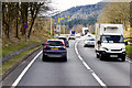
3

Perth and Kinross : The A9
Heading along the A9 and apssing a bus on its way to Inverness.
Image: © Lewis Clarke
Taken: 25 Apr 2016
0.08 miles
6
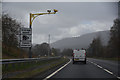
Perth and Kinross : The A9
Average speed cameras on the A9 road.
Image: © Lewis Clarke
Taken: 25 Apr 2016
0.11 miles
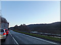
7
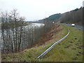
The A9 running parallel to the River Tay
The trees beside the road are growing up and obscuring the view.
Motorists travelling along this stretch of the A9 have seen ospreys taking fish from the river.
Image: © Russel Wills
Taken: 8 Feb 2012
0.14 miles
8
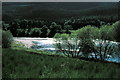
River Tay - 1980
River Tay, seen from the A9 opposite Dalmarnock.
The River Tay is the longest river in Scotland and the seventh-longest in the United Kingdom. The Tay originates in western Scotland on the slopes of Ben Lui, then flows easterly across the Highlands, through Loch Dochhart, Loch Lubhair and Loch Tay, then continues east through Strathtay, in the centre of Scotland, then southeasterly through Perth, where it becomes tidal, to its mouth at the Firth of Tay, south of Dundee.
Image: © Helmut Zozmann
Taken: Unknown
0.14 miles
9
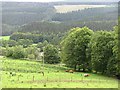
Cattle, Tom Ban
This little lot Image seen from the old A9 on the east side of the Tay.
Image: © Richard Webb
Taken: 18 Jul 2011
0.15 miles
10
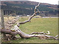
Flood debris
The view of drift wood and other flotsam and jetsam left behind on the man made flood defence on the western bank of the River Tay. In the distance the buildings from left to right are Dalmarnock, the farm buildings at Dalmarnock and the house on the bend in the road Image To the north of these buildings the repairs to the eastern side of the railway embankment can be seen (as undertaken from the construction site on the west side of the embankment Image).
Image: © Sandy Gemmill
Taken: 25 Mar 2008
0.16 miles