IMAGES TAKEN NEAR TO
Logierait, PITLOCHRY, PH9 0LJ
Introduction
This page details the photographs taken nearby to PH9 0LJ by members of the Geograph project.
The Geograph project started in 2005 with the aim of publishing, organising and preserving representative images for every square kilometre of Great Britain, Ireland and the Isle of Man.

There are currently over 7.5m images from over14,400 individuals and you can help contribute to the project by visiting https://www.geograph.org.uk
Image Map
Images are licensed for reuse under creativecommons.org/licenses/by-sa/2.0
Notes
- Clicking on the map will re-center to the selected point.
- The higher the marker number, the further away the image location is from the centre of the postcode.
Image Listing (64 Images Found)
Images are licensed for reuse under creativecommons.org/licenses/by-sa/2.0
Image
Details
Distance
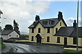
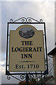
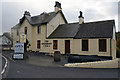
4
The Logierait Inn
2-storey basement and attic, white-washed rubble broad eaves, centre gable; c.1835. Hall extension at rear.
Grade C listed. Listing number LB13788.
Image: © Andrew Abbott
Taken: 17 Aug 2020
0.00 miles
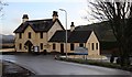
6
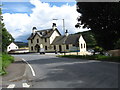
The Logierait Inn
Another ancient inn on the banks of the River Tay.
Image: © James Denham
Taken: 29 Jul 2012
0.01 miles
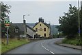
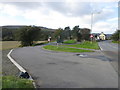
7
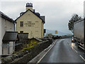
Logierait
The A827 passing through Logierait, with the Logierait Inn ahead.
Image: © David Dixon
Taken: 24 Oct 2011
0.04 miles
8
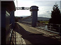
Old Logierait Bridge
Re-opened for vehicular traffic in 2001 after restoration
Image: © Donald Watson
Taken: 23 Sep 2006
0.04 miles
10
Road to Logierait Bridge
The road leading to Logierait Bridge off the A827 on the eastern side of Logierait.
Image: © Scott Cormie
Taken: 2 Oct 2018
0.07 miles