IMAGES TAKEN NEAR TO
DUNKELD, PH8 0RE
Introduction
This page details the photographs taken nearby to PH8 0RE by members of the Geograph project.
The Geograph project started in 2005 with the aim of publishing, organising and preserving representative images for every square kilometre of Great Britain, Ireland and the Isle of Man.

There are currently over 7.5m images from over14,400 individuals and you can help contribute to the project by visiting https://www.geograph.org.uk
Image Map
Images are licensed for reuse under creativecommons.org/licenses/by-sa/2.0
Notes
- Clicking on the map will re-center to the selected point.
- The higher the marker number, the further away the image location is from the centre of the postcode.
Image Listing (3 Images Found)
Images are licensed for reuse under creativecommons.org/licenses/by-sa/2.0
Image
Details
Distance
1
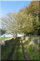
An old road, Kincairney
The last of this year's leaves are about to fall from the ash beside an old, occasionally used track.
Image: © Richard Webb
Taken: 30 Oct 2016
0.21 miles
2
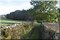
Old road, Kincairney
Still in use, but not frequently.
Image: © Richard Webb
Taken: 30 Oct 2016
0.22 miles
3
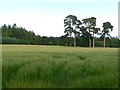
Pines among the barley
A field near Kincairney House.
Image: © James Allan
Taken: 21 Jul 2008
0.24 miles