IMAGES TAKEN NEAR TO
King Duncans Place, DUNKELD, PH8 0QD
Introduction
This page details the photographs taken nearby to King Duncans Place, PH8 0QD by members of the Geograph project.
The Geograph project started in 2005 with the aim of publishing, organising and preserving representative images for every square kilometre of Great Britain, Ireland and the Isle of Man.

There are currently over 7.5m images from over14,400 individuals and you can help contribute to the project by visiting https://www.geograph.org.uk
Image Map
Images are licensed for reuse under creativecommons.org/licenses/by-sa/2.0
Notes
- Clicking on the map will re-center to the selected point.
- The higher the marker number, the further away the image location is from the centre of the postcode.
Image Listing (80 Images Found)
Images are licensed for reuse under creativecommons.org/licenses/by-sa/2.0
Image
Details
Distance
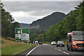
2
A9, Little Dunkeld
Heading south east towards Perth.
Image: © JThomas
Taken: 10 May 2014
0.04 miles
4
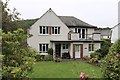
Houses on Stell Park Road
In Little Dunkeld
Image: © Andrew Abbott
Taken: 15 Aug 2020
0.07 miles
5
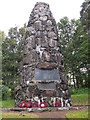
Dunkeld memorial
The memorial is on a hill overlooking Dunkeld.
Image: © william
Taken: 7 Sep 2011
0.10 miles
6
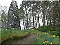
War Memorial
Flower bordered path leading to the War Memorial at Little Dunkeld
Image: © Liz Gray
Taken: 1 May 2010
0.10 miles
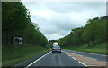
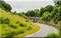
8
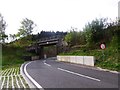
A822 leaving Little Dunkeld
Passing under the railway to Inverness.
Image: © Stanley Howe
Taken: 16 May 2014
0.12 miles
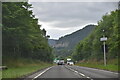
9
Railway bridge over A822 at (Little) Dunkeld
The bridge is over the A822 just west of the station named Dunkeld and Birnam.
Image: © Trevor Littlewood
Taken: 3 Jul 2021
0.12 miles
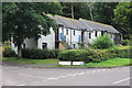
10
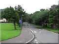
Road, Little Dunkeld
A small road beside The Royal School of Dunkeld.
Image: © Richard Webb
Taken: 18 Jul 2011
0.12 miles