IMAGES TAKEN NEAR TO
Dalguise, DUNKELD, PH8 0LA
Introduction
This page details the photographs taken nearby to PH8 0LA by members of the Geograph project.
The Geograph project started in 2005 with the aim of publishing, organising and preserving representative images for every square kilometre of Great Britain, Ireland and the Isle of Man.

There are currently over 7.5m images from over14,400 individuals and you can help contribute to the project by visiting https://www.geograph.org.uk
Image Map
Images are licensed for reuse under creativecommons.org/licenses/by-sa/2.0
Notes
- Clicking on the map will re-center to the selected point.
- The higher the marker number, the further away the image location is from the centre of the postcode.
Image Listing (12 Images Found)
Images are licensed for reuse under creativecommons.org/licenses/by-sa/2.0
Image
Details
Distance
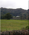
1
Castle Peroch
A house where farmland gives way to vast woodlands.
Image: © Richard Webb
Taken: 18 Jul 2011
0.01 miles
3
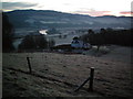
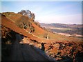
Above Kincraigie
Looking SE across Strath Tay at first light
Image: © Rob Woodall
Taken: 3 Jan 2009
0.06 miles
4
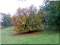
Autumn leaves at Kincraigie
This tree has begun to shed its leaves quite early in comparison to the surrounding ones.
Image: © Dave Fergusson
Taken: 28 Sep 2010
0.13 miles
5
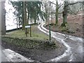
Icy track to Castle Peroch
Beside the woods opposite Kinnaird House.
Image: © Russel Wills
Taken: 8 Feb 2012
0.16 miles
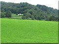
8
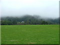
Farmland under low cloud
At Kincraigie.
Image: © Dave Fergusson
Taken: 28 Sep 2010
0.20 miles
9
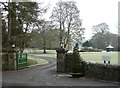
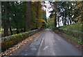
Gateway to Kinnaird Estate
From the B898.
Image: © Russel Wills
Taken: 8 Feb 2012
0.20 miles
10
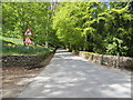
Road (B898) at the entrance to Kinnaird House
Looking north-westward.
Image: © Peter Wood
Taken: 3 May 2019
0.20 miles