IMAGES TAKEN NEAR TO
DUNKELD, PH8 0JB
Introduction
This page details the photographs taken nearby to PH8 0JB by members of the Geograph project.
The Geograph project started in 2005 with the aim of publishing, organising and preserving representative images for every square kilometre of Great Britain, Ireland and the Isle of Man.

There are currently over 7.5m images from over14,400 individuals and you can help contribute to the project by visiting https://www.geograph.org.uk
Image Map
Images are licensed for reuse under creativecommons.org/licenses/by-sa/2.0
Notes
- Clicking on the map will re-center to the selected point.
- The higher the marker number, the further away the image location is from the centre of the postcode.
Image Listing (8 Images Found)
Images are licensed for reuse under creativecommons.org/licenses/by-sa/2.0
Image
Details
Distance
1
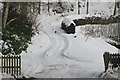
Driveway to Thornton, between Dunkeld and Caputh
Two Pheasants are foraging along the track.
Image: © Mike Pennington
Taken: 29 Dec 2009
0.01 miles
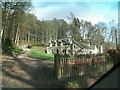
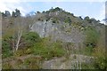
3
Kemp's Hold
This rocky crag was the site of an ancient fort; well positioned to guard the track along the north bank of the Tay
Image: © John McMillan
Taken: 13 Mar 2007
0.14 miles
4
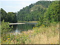
River Tay
This stretch of the Tay lies upstream from Caputh Bridge. The yellow flowers on the river bank are Tansy plants.
Image: © Frank Smith
Taken: 6 Jun 2021
0.14 miles
5
Kemp's Hold
Above the crag is the site of a fort.
Image: © Richard Webb
Taken: 30 Oct 2016
0.16 miles
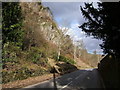
6
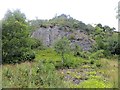
Craig of Stenton
A foreshortened view of a steep, rotten crag beneath the fort of Kemp's Hold.
Image: © Richard Webb
Taken: 6 Sep 2013
0.16 miles
7
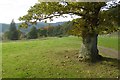
Road above Thornton
A track connecting scattered dwellings north of Caputh.
Image: © Richard Webb
Taken: 30 Oct 2016
0.24 miles
8
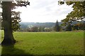
Above Thornton
A field above the Tay downstream from Dunked/Birnam.
Image: © Richard Webb
Taken: 30 Oct 2016
0.25 miles