IMAGES TAKEN NEAR TO
DUNKELD, PH8 0HD
Introduction
This page details the photographs taken nearby to PH8 0HD by members of the Geograph project.
The Geograph project started in 2005 with the aim of publishing, organising and preserving representative images for every square kilometre of Great Britain, Ireland and the Isle of Man.

There are currently over 7.5m images from over14,400 individuals and you can help contribute to the project by visiting https://www.geograph.org.uk
Image Map
Images are licensed for reuse under creativecommons.org/licenses/by-sa/2.0
Notes
- Clicking on the map will re-center to the selected point.
- The higher the marker number, the further away the image location is from the centre of the postcode.
Image Listing (8 Images Found)
Images are licensed for reuse under creativecommons.org/licenses/by-sa/2.0
Image
Details
Distance
1
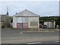
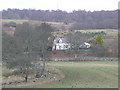
Former garage, Old Laighwood
Long closed filling station on what appears to be a quiet road.
Image: © Richard Webb
Taken: 6 Sep 2013
0.01 miles
5
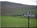
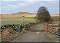
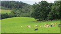
Field along the entrance to Old Laighwood
The entrance sign, field and lower hill slopes are in the subject grid square, while the upper slopes are in the grid square to the north.
Image: © C Michael Hogan
Taken: 28 Jul 2012
0.10 miles
8
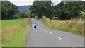
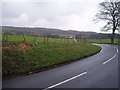
The dark side
A recumbent bicycle on the A923. Not so great at climbing, but on a flattish road like this, they are like the proverbial off a shovel.
Image: © Richard Webb
Taken: 6 Sep 2013
0.20 miles