IMAGES TAKEN NEAR TO
DUNKELD, PH8 0DX
Introduction
This page details the photographs taken nearby to PH8 0DX by members of the Geograph project.
The Geograph project started in 2005 with the aim of publishing, organising and preserving representative images for every square kilometre of Great Britain, Ireland and the Isle of Man.

There are currently over 7.5m images from over14,400 individuals and you can help contribute to the project by visiting https://www.geograph.org.uk
Image Map
Images are licensed for reuse under creativecommons.org/licenses/by-sa/2.0
Notes
- Clicking on the map will re-center to the selected point.
- The higher the marker number, the further away the image location is from the centre of the postcode.
Image Listing (20 Images Found)
Images are licensed for reuse under creativecommons.org/licenses/by-sa/2.0
Image
Details
Distance
1
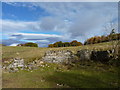
Trackside ruin
Old walls beside the track towards Balhomish farm.
Image: © James Allan
Taken: 29 Oct 2012
0.09 miles
2
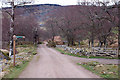
Track junction near Tomgarrow
The Braan Path turns here on the route back to The Hermitage or Inver.
Image: © Jim Barton
Taken: 16 Mar 2012
0.12 miles
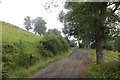
3
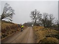
Road to Tomgarrow and Balhormish
An unsealed road in good condition. It is part of a network of waymarked paths around Birnam.
Image: © Richard Webb
Taken: 13 Apr 2013
0.12 miles
4
Braan Path near Tomgarrow
The route follows this track into the plantations at Ladywell. The crags at Craig a Barns can be seen on the wooded hillside across the Tay.
Image: © Jim Barton
Taken: 16 Mar 2012
0.12 miles
5
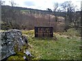
Z Coy HSF
I confess I had never heard about the HSF before encountering this mysterious sign. More information and an anecdote: Image Z Coy was the Perth stationed company, I have no insights as to why this sign was erected specifically here.
Image: © Aleks Scholz
Taken: 11 Apr 2023
0.13 miles
6
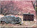
Who do you think you are kidding, Mr Andropov?
Little is remembered about Michael Hesseltine's version of the Home Guard. During the Cold War the Home Service Force was raised (1982-92) to provide a group ex military who could be used to guard key infrastructure installations from East European special forces. This was erected by or on behalf of Z (HSF) Coy 1st (V) Bn, 51st Highland Volunteers, Black Watch (The Royal Highland Regt).
My only contact with this organisation was in taking part in a real life Dad's Army episode in 1991. I was taking part in a pub quiz for a climbing club after a day climbing on Mayar, and two of the opposition teams were representing the HSF. We won, and their "commanding officer" was distinctly upset and gave a performance Arthur Lowe would have been proud of. We assume that was because three of the team were English, at least half CND supporters, one had been on University Challenge, and some lack of deference to a local celebrity landowner (clue: liked gin and lived to 101). One of the best pub nights ever. The trophy still resides in the club hut in Deiniolen.
The vanquished may well have been from this unit.
Image: © Richard Webb
Taken: 13 Apr 2013
0.14 miles
7
Tomgarrow and Balhomish road
A farm access road is used by the Birnam path network.
Image: © Richard Webb
Taken: 29 Aug 2015
0.15 miles
8
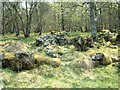
Lost village
These stones, overgrown by the forest moss and grass, are all that now remains of a small village near Tomgarrow. Until about 100 years ago it housed the men who worked the nearby slate quarries but was abandoned when the quarries were worked out.
Image: © James Allan
Taken: 8 May 2006
0.15 miles
9
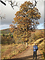
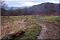
Autumn near Rumbling Bridge
Looking back towards Rumbling Bridge from the track to Tomgarrow.
Image: © Lis Burke
Taken: 31 Oct 2009
0.16 miles
10
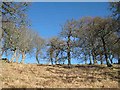
Trees on a bank
Looking up the bank adjacent to the farm track leading to Tomgarrow and Balhomish. The bright blue sky was a very welcome sight after a succession of squally snow showers.
Image: © Lis Burke
Taken: 24 Mar 2008
0.17 miles