IMAGES TAKEN NEAR TO
Amulree, DUNKELD, PH8 0BY
Introduction
This page details the photographs taken nearby to PH8 0BY by members of the Geograph project.
The Geograph project started in 2005 with the aim of publishing, organising and preserving representative images for every square kilometre of Great Britain, Ireland and the Isle of Man.

There are currently over 7.5m images from over14,400 individuals and you can help contribute to the project by visiting https://www.geograph.org.uk
Image Map
Images are licensed for reuse under creativecommons.org/licenses/by-sa/2.0
Notes
- Clicking on the map will re-center to the selected point.
- The higher the marker number, the further away the image location is from the centre of the postcode.
Image Listing (5 Images Found)
Images are licensed for reuse under creativecommons.org/licenses/by-sa/2.0
Image
Details
Distance
1
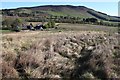
Dalreoch
A centre offering outdoor activities.
Image: © Alan Reid
Taken: 12 May 2019
0.03 miles
2
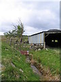
Old cattle shed by Dalreoch
Disused shed by Dalreoch farm house. Adjacent small ditch/burn draining off hillside. Area still used for rough cattle grazing and excellent area for breeding curlew and lapwing.
Image: © Helen Taylor
Taken: 7 May 2007
0.10 miles
4
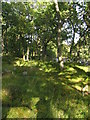
Island at Glenfender/ Braan confluence
This small triangular island is formed by the confluence of the River Braan and the Glenfender Burn. It is covered with oak woodland, with an understorey of regenerating rowan and birch and blaeberry and moss ground flora.
Image: © Helen Taylor
Taken: 21 Sep 2007
0.24 miles
5
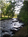
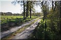
River Braan by Glenfender Cottage
The River Braan passes joins the Glenfender Burn just downstream of this point. The trees on the right are on the small wooded island which is formed at the confluence of the two watercourses.
Image: © Helen Taylor
Taken: 21 Sep 2007
0.24 miles