IMAGES TAKEN NEAR TO
DUNKELD, PH8 0BP
Introduction
This page details the photographs taken nearby to PH8 0BP by members of the Geograph project.
The Geograph project started in 2005 with the aim of publishing, organising and preserving representative images for every square kilometre of Great Britain, Ireland and the Isle of Man.

There are currently over 7.5m images from over14,400 individuals and you can help contribute to the project by visiting https://www.geograph.org.uk
Image Map
Images are licensed for reuse under creativecommons.org/licenses/by-sa/2.0
Notes
- Clicking on the map will re-center to the selected point.
- The higher the marker number, the further away the image location is from the centre of the postcode.
Image Listing (16 Images Found)
Images are licensed for reuse under creativecommons.org/licenses/by-sa/2.0
Image
Details
Distance
1
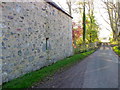
Minor road at Lagganallachie
On the angle of the building beside the minor road is an Ordnance Survey bench mark.
Image: © Maigheach-gheal
Taken: 1 Nov 2011
0.00 miles
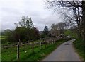
2

Old Military Road by Lagganallachie
From near the old Burial Ground (wall on left). A Collie sheepdog showed mild interest in me as I approached, by raising its head without bothering to get up!
Image: © Stanley Howe
Taken: 16 May 2014
0.00 miles
3
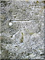
Bench Mark, Lagganallachie
The Ordnance Survey bench mark is on the north west angle of the building. For a wider view of the building Image and for further information on the cut mark and others in the area http://www.bench-marks.org.uk/bm40411
Image: © Maigheach-gheal
Taken: 1 Nov 2011
0.01 miles
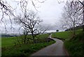
4
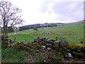
Old Burial Ground, Lagganallachie
By the Old Military Road.
Image: © Stanley Howe
Taken: 16 May 2014
0.04 miles
5
Bridge over the Logie Burn
On an Old Military Road through Strath Braan.
Image: © Stanley Howe
Taken: 16 May 2014
0.06 miles
6
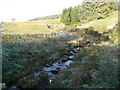
Logie Burn
Heading for the River Braan.
Image: © Russel Wills
Taken: 17 Oct 2009
0.08 miles
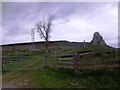
7
Communications mast
In fields where remains of old farmsteads are mapped.
Image: © Stanley Howe
Taken: 16 May 2014
0.11 miles
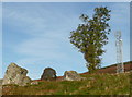
8
Vegetable and Mineral
A lone tree betwixt a metal communications mast and a ruined stone farmstead. Seen from the entrance gate to the telecoms mast.
Image: © Stanley Howe
Taken: 16 May 2014
0.11 miles
9
Communications mast
With rock outcrop and battered tree from an earlier age.
Image: © Russel Wills
Taken: 17 Oct 2009
0.12 miles
10
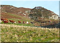
Cattle on a frosty morning
Craig Laggan beyond.
Image: © Russel Wills
Taken: 17 Oct 2009
0.18 miles