IMAGES TAKEN NEAR TO
Water Wynd, DUNKELD, PH8 0AP
Introduction
This page details the photographs taken nearby to Water Wynd, PH8 0AP by members of the Geograph project.
The Geograph project started in 2005 with the aim of publishing, organising and preserving representative images for every square kilometre of Great Britain, Ireland and the Isle of Man.

There are currently over 7.5m images from over14,400 individuals and you can help contribute to the project by visiting https://www.geograph.org.uk
Image Map
Images are licensed for reuse under creativecommons.org/licenses/by-sa/2.0
Notes
- Clicking on the map will re-center to the selected point.
- The higher the marker number, the further away the image location is from the centre of the postcode.
Image Listing (364 Images Found)
Images are licensed for reuse under creativecommons.org/licenses/by-sa/2.0
Image
Details
Distance

2
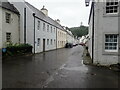
Little Houses
The National Trust owns these properties adjacent to Dunkeld cathedral.
Image: © Andrew Wood
Taken: 10 Jul 1995
0.01 miles
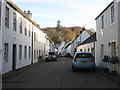
3

Water Wynd, Dunkeld
Leading from Cathedral Street, and used by monks to haul their boats up from the River Tay.
Image: © M J Richardson
Taken: 18 Nov 2017
0.01 miles
4
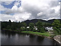
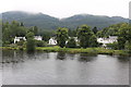
Dunkeld, West
The white houses of the west side of Dunkeld. A playpark for children can be seen between the trees on the right. Taken from Telford's Bridge, small part in foreground. Dunkeld Cathedral is hidden by the trees on the far left. The hill in the background is Craig a Barns.
Image: © Dona Robbins
Taken: 19 Jun 2012
0.02 miles
5

Water Wynd, Dunkeld
This and other wynds provided access to the water supply of the River Tay from the town centre before piped water came to Dunkeld in the mid 1800's.
Image: © Richard Dorrell
Taken: 21 Sep 2009
0.02 miles
6
Cathedral Street, Dunkeld
Looking east from the entrance to the cathedral grounds.
Image: © M J Richardson
Taken: 18 Nov 2017
0.02 miles
7
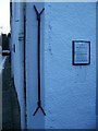
The "Ell" on the side of the National Trust for Scotland shop.
Apart from being a handy word for "Scrabble" players, the ell was a unit of length standardised in 1661 at 37 inches.
See Image
Image: © Elliott Simpson
Taken: 24 Jan 2009
0.02 miles
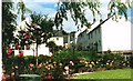
9
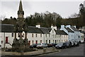
Dunkeld
Looking east from near the Cathedral, and past the Atholl Memorial Fountain.
Image: © Mike Pennington
Taken: 30 Mar 2010
0.02 miles