IMAGES TAKEN NEAR TO
Bridle Way, CRIEFF, PH7 4LL
Introduction
This page details the photographs taken nearby to Bridle Way, PH7 4LL by members of the Geograph project.
The Geograph project started in 2005 with the aim of publishing, organising and preserving representative images for every square kilometre of Great Britain, Ireland and the Isle of Man.

There are currently over 7.5m images from over14,400 individuals and you can help contribute to the project by visiting https://www.geograph.org.uk
Image Map
Images are licensed for reuse under creativecommons.org/licenses/by-sa/2.0
Notes
- Clicking on the map will re-center to the selected point.
- The higher the marker number, the further away the image location is from the centre of the postcode.
Image Listing (85 Images Found)
Images are licensed for reuse under creativecommons.org/licenses/by-sa/2.0
Image
Details
Distance
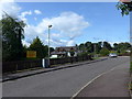
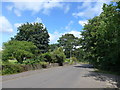
2
Horseshoe Drive From Laggan Road
Across a dry-stone wall and a newly growing crop to the new housing development on the outskirts of Crieff.
Image: © Martin Addison
Taken: 6 May 2011
0.06 miles

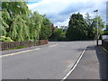
4
Junction of Horseshoe Drive and Laggan Road
Image: © Basher Eyre
Taken: 13 Aug 2014
0.08 miles
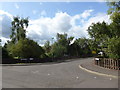
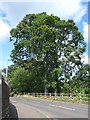
5
Looking from Horseshoe Drive into Laggan Road
Image: © Basher Eyre
Taken: 13 Aug 2014
0.08 miles
6
Looking along Laggan Road towards Turretbank Road
Image: © Basher Eyre
Taken: 13 Aug 2014
0.09 miles
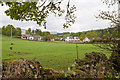
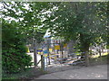
7

Outskirts of Crieff
Approaching the W side of Crieff from Lady Mary's Walk.
Image: © Jim Barton
Taken: 8 Oct 2010
0.09 miles
10
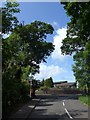
Approaching the junction of Turretbank Road and Laggan Road
Image: © Basher Eyre
Taken: 13 Aug 2014
0.10 miles