IMAGES TAKEN NEAR TO
Mill Wynd, Mill Road, CRIEFF, PH7 4FG
Introduction
This page details the photographs taken nearby to Mill Wynd, Mill Road, PH7 4FG by members of the Geograph project.
The Geograph project started in 2005 with the aim of publishing, organising and preserving representative images for every square kilometre of Great Britain, Ireland and the Isle of Man.

There are currently over 7.5m images from over14,400 individuals and you can help contribute to the project by visiting https://www.geograph.org.uk
Image Map
Images are licensed for reuse under creativecommons.org/licenses/by-sa/2.0
Notes
- Clicking on the map will re-center to the selected point.
- The higher the marker number, the further away the image location is from the centre of the postcode.
Image Listing (265 Images Found)
Images are licensed for reuse under creativecommons.org/licenses/by-sa/2.0
Image
Details
Distance
1
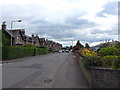
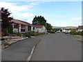
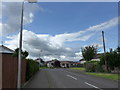
Looking southwards down Sauchie Road
(from its crossroads with Mill Road and Sauchie Place)
Image: © Basher Eyre
Taken: 13 Aug 2014
0.05 miles
2
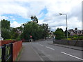
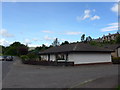
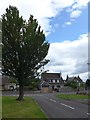
Approaching the crossroads of Sauchie Place, Sauchie Road and Mill Road
Image: © Basher Eyre
Taken: 13 Aug 2014
0.08 miles
3
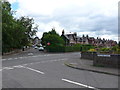
Crossroads of Sauchie Place, Sauchie Road and Mill Street
Image: © Basher Eyre
Taken: 13 Aug 2014
0.08 miles
6
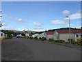
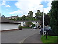
Junction of Sauchie Road and Glen Ogle Court
Image: © Basher Eyre
Taken: 13 Aug 2014
0.09 miles
7
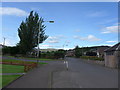
Looking from Sauchie Road into Glen Ogle Court
Image: © Basher Eyre
Taken: 13 Aug 2014
0.09 miles
8
Approaching the junction of Sauchie Road and Sauchie Place
Image: © Basher Eyre
Taken: 13 Aug 2014
0.09 miles
10
Looking back from Sauchie Place towards Sauchie Road
Image: © Basher Eyre
Taken: 13 Aug 2014
0.09 miles