IMAGES TAKEN NEAR TO
Heathcote Road, CRIEFF, PH7 4AS
Introduction
This page details the photographs taken nearby to Heathcote Road, PH7 4AS by members of the Geograph project.
The Geograph project started in 2005 with the aim of publishing, organising and preserving representative images for every square kilometre of Great Britain, Ireland and the Isle of Man.

There are currently over 7.5m images from over14,400 individuals and you can help contribute to the project by visiting https://www.geograph.org.uk
Image Map
Images are licensed for reuse under creativecommons.org/licenses/by-sa/2.0
Notes
- Clicking on the map will re-center to the selected point.
- The higher the marker number, the further away the image location is from the centre of the postcode.
Image Listing (198 Images Found)
Images are licensed for reuse under creativecommons.org/licenses/by-sa/2.0
Image
Details
Distance
1
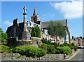
St Ninian's Court
Formerly Crieff West Parish Church (St Ninian's) it is now converted into residential apartments.
Image: © David Dixon
Taken: 24 Oct 2011
0.01 miles
2
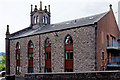
St Ninians Church Apartments
This is the former Crieff West Parish Church. It became a Church of Scotland conference centre, and is now converted into apartments.
Image: © Rob Burke
Taken: 14 Jun 2011
0.02 miles
5
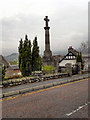
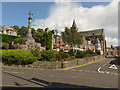
Approaching the eastern end of Milnab Street
Image: © Basher Eyre
Taken: 13 Aug 2014
0.05 miles
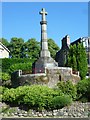
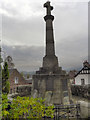
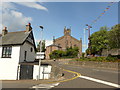
6
Junction of Milnab Street and Comrie Street
Image: © Basher Eyre
Taken: 13 Aug 2014
0.05 miles
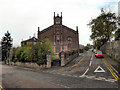
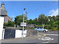
7
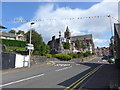
Looking from Milnab Street into Comrie Street
Image: © Basher Eyre
Taken: 13 Aug 2014
0.05 miles