IMAGES TAKEN NEAR TO
PH7 3YQ
Introduction
This page details the photographs taken nearby to PH7 3YQ by members of the Geograph project.
The Geograph project started in 2005 with the aim of publishing, organising and preserving representative images for every square kilometre of Great Britain, Ireland and the Isle of Man.

There are currently over 7.5m images from over14,400 individuals and you can help contribute to the project by visiting https://www.geograph.org.uk
Image Map
Images are licensed for reuse under creativecommons.org/licenses/by-sa/2.0
Notes
- Clicking on the map will re-center to the selected point.
- The higher the marker number, the further away the image location is from the centre of the postcode.
Image Listing (22 Images Found)
Images are licensed for reuse under creativecommons.org/licenses/by-sa/2.0
Image
Details
Distance
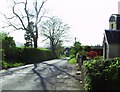
1
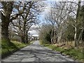
Minor road at Tomaknock on outskirts of Crieff
Image: © Douglas Nelson
Taken: 20 Apr 2017
0.03 miles
2
Tomaknock
Looking west along the road from East Tomaknock
Image: © Alan Douiglas
Taken: 26 Apr 2007
0.06 miles
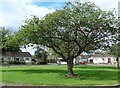
3
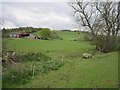
Wester Tomaknock
Farmland on the edge of Crieff.
Image: © Richard Webb
Taken: 16 May 2013
0.09 miles
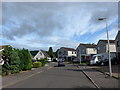
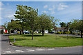
4
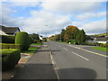
Dollerie Terrace, Crieff
The C410 road heading west along Dollerie Terrace towards the town centre of Crieff.
Image: © Scott Cormie
Taken: 11 Oct 2020
0.13 miles
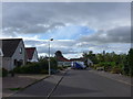
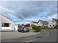
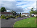
7
Hollybush Crescent
The bungalows are grouped around an open space.
Image: © Rob Burke
Taken: 14 Jun 2011
0.21 miles