IMAGES TAKEN NEAR TO
CRIEFF, PH7 3QW
Introduction
This page details the photographs taken nearby to PH7 3QW by members of the Geograph project.
The Geograph project started in 2005 with the aim of publishing, organising and preserving representative images for every square kilometre of Great Britain, Ireland and the Isle of Man.

There are currently over 7.5m images from over14,400 individuals and you can help contribute to the project by visiting https://www.geograph.org.uk
Image Map
Images are licensed for reuse under creativecommons.org/licenses/by-sa/2.0
Notes
- Clicking on the map will re-center to the selected point.
- The higher the marker number, the further away the image location is from the centre of the postcode.
Image Listing (8 Images Found)
Images are licensed for reuse under creativecommons.org/licenses/by-sa/2.0
Image
Details
Distance
2
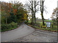
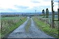
The B8062 at Millhills
Heading for Crieff, as the sign implies!
Image: © David Purchase
Taken: 2 Nov 2011
0.07 miles
3
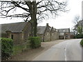
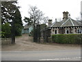
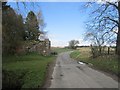
Farm buildings at Millhills
Extensive buildings with crow-stepped gables, on the B8062 between Crieff and Kinkell Bridge.
Image: © M J Richardson
Taken: 7 Apr 2017
0.09 miles
4
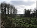
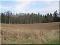
Millhills
Rather rashy ground seen from the B8062.
Image: © Richard Webb
Taken: 24 Apr 2013
0.13 miles
7
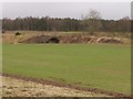
Site of Innerpeffray Station
Bridge buttress on the site of the railway between Perth and Crieff. The station was to the left (west).
Image: © Richard Webb
Taken: 24 Apr 2013
0.22 miles
8
Railway bridge by Innerpeffery Station
Line of the old railway on its approach to Innerpeffery station. The station lies some 200 mts to right of shot but Innerpeffery is over 1500mts away to the south!
Image: © Jim Bain
Taken: 2 Apr 2006
0.25 miles