IMAGES TAKEN NEAR TO
Madderty, CRIEFF, PH7 3PP
Introduction
This page details the photographs taken nearby to PH7 3PP by members of the Geograph project.
The Geograph project started in 2005 with the aim of publishing, organising and preserving representative images for every square kilometre of Great Britain, Ireland and the Isle of Man.

There are currently over 7.5m images from over14,400 individuals and you can help contribute to the project by visiting https://www.geograph.org.uk
Image Map
Images are licensed for reuse under creativecommons.org/licenses/by-sa/2.0
Notes
- Clicking on the map will re-center to the selected point.
- The higher the marker number, the further away the image location is from the centre of the postcode.
Image Listing (9 Images Found)
Images are licensed for reuse under creativecommons.org/licenses/by-sa/2.0
Image
Details
Distance
1
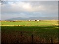
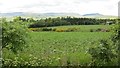
Farmland from Gask Ridge
Looking northwest towards West Bank farm, from near Ardunie Watchtower
Image: © Jackie Proven
Taken: 23 Dec 2005
0.04 miles
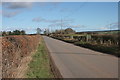
3
Road near Westbank
Looking to the southwest.
Image: © Richard Sutcliffe
Taken: 20 Feb 2017
0.09 miles
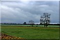
4
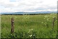
Grass field, St David's
A break from the usual tatties, wheat and barley grown around here. The grass will soon be cut for silage.
Image: © Richard Webb
Taken: 21 Jun 2015
0.14 miles
5
Bean crop, St David's
View towards the Highland Boundary Fault.
Image: © Richard Webb
Taken: 21 Jun 2015
0.15 miles
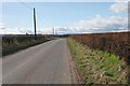
6
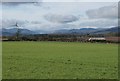
Grassy field southwest of St David's
Glen Artney and its surrounding hills are in the far distance.
Image: © Richard Sutcliffe
Taken: 20 Feb 2017
0.17 miles
7
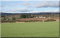
Fields southwest of St David's
Looking towards Craigmuir in the distance, which appears to have lost half of its roof.
Image: © Richard Sutcliffe
Taken: 20 Feb 2017
0.22 miles
9
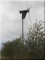
Wind turbine at Sauchie Farm
There are also solar panels on some of the farm buildings.
Image: © M J Richardson
Taken: 9 Apr 2017
0.24 miles