IMAGES TAKEN NEAR TO
CRIEFF, PH7 3NX
Introduction
This page details the photographs taken nearby to PH7 3NX by members of the Geograph project.
The Geograph project started in 2005 with the aim of publishing, organising and preserving representative images for every square kilometre of Great Britain, Ireland and the Isle of Man.

There are currently over 7.5m images from over14,400 individuals and you can help contribute to the project by visiting https://www.geograph.org.uk
Image Map
Images are licensed for reuse under creativecommons.org/licenses/by-sa/2.0
Notes
- Clicking on the map will re-center to the selected point.
- The higher the marker number, the further away the image location is from the centre of the postcode.
Image Listing (15 Images Found)
Images are licensed for reuse under creativecommons.org/licenses/by-sa/2.0
Image
Details
Distance
1
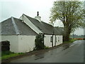
Tuchethill Cottage
Typical roadside agricultural cottage
Image: © James Allan
Taken: 15 May 2006
0.03 miles
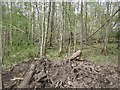
4
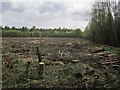
Long Plantation
A recently felled block.
Image: © Richard Webb
Taken: 16 May 2013
0.18 miles
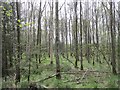
5
Long Plantation
Woodland, here on wet ground with a lot of willow.
Image: © Richard Webb
Taken: 16 May 2013
0.19 miles
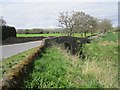
7
Long Plantation
North of the road, to the south there is now a large clear felled area.
Image: © Richard Webb
Taken: 16 May 2013
0.20 miles
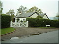
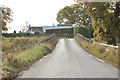
8
Dollerie Bridge
A bridge over the Pow Water which is as usual a drain.
Image: © Richard Webb
Taken: 16 May 2013
0.22 miles
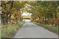
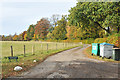
10
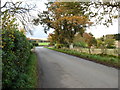
A minor road near Dollerie
Dollerie Bridge across Pow Water, a tributary of the River Almond, is just round the bend to the right.
Image: © David Purchase
Taken: 2 Nov 2011
0.23 miles