IMAGES TAKEN NEAR TO
Garry Place, CRIEFF, PH6 2PD
Introduction
This page details the photographs taken nearby to Garry Place, PH6 2PD by members of the Geograph project.
The Geograph project started in 2005 with the aim of publishing, organising and preserving representative images for every square kilometre of Great Britain, Ireland and the Isle of Man.

There are currently over 7.5m images from over14,400 individuals and you can help contribute to the project by visiting https://www.geograph.org.uk
Image Map
Images are licensed for reuse under creativecommons.org/licenses/by-sa/2.0
Notes
- Clicking on the map will re-center to the selected point.
- The higher the marker number, the further away the image location is from the centre of the postcode.
Image Listing (18 Images Found)
Images are licensed for reuse under creativecommons.org/licenses/by-sa/2.0
Image
Details
Distance
2
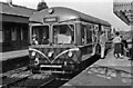
BR Diesel railbus at Comrie, 1959
View east, towards Crieff, from which the railbus had come since 9/58. An early example of Modernisation, before that the branch from Crieff to Comrie had been steam-worked, running through to Lochearnhead until 1/10/51; Crieff - Comrie was nevertheless closed 6/7/64.
Image: © Walter Dendy, deceased
Taken: 20 Jun 1959
0.13 miles
3
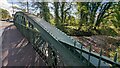
Site of Comrie station, 1988
View eastward, towards Crieff and Perth/Gleneagles: ex-Caledonian line from Balquhidder. The line from Balquhidder had been closed long before (1/10/51), but Comrie station remained until 6/7/64 when the line to Crieff was abandoned. Comrie is noted as a beautiful place for retirement, evidenced here by the whole station site being converted into a colony of mobile homes.
Image: © Ben Brooksbank
Taken: 14 Jun 1988
0.16 miles
4
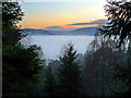
Misty Strathearn
A temperature inversion has filled the Strath with mist, hiding the farmland and the village of Comrie.
Image: © Dr Richard Murray
Taken: 11 Dec 2009
0.19 miles
6
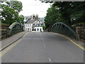
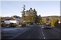
Bridge of Lednock
Entering Comrie from the east along the A85 at the point where the road crosses the River Lednock.
Image: © G Laird
Taken: 17 Jul 2012
0.21 miles
8
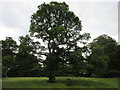
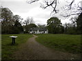
The Oak Tree
Oak Tree planted by Colonel Williamson of Lawers in 1902 in honour of the King, at the rear of St.Serf's Church.
Image: © Scott Cormie
Taken: 2 Aug 2017
0.21 miles
9
St Serf's Episcopal Church
St Serf's viewed from the A85 in Comrie.
Image: © Scott Cormie
Taken: 2 Aug 2017
0.22 miles
10
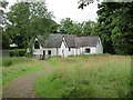
St Serf's from the rear
St Serf's Episcopal Church from the meadow to the rear.
Image: © Scott Cormie
Taken: 2 Aug 2017
0.22 miles