IMAGES TAKEN NEAR TO
Dundas Street, CRIEFF, PH6 2LN
Introduction
This page details the photographs taken nearby to Dundas Street, PH6 2LN by members of the Geograph project.
The Geograph project started in 2005 with the aim of publishing, organising and preserving representative images for every square kilometre of Great Britain, Ireland and the Isle of Man.

There are currently over 7.5m images from over14,400 individuals and you can help contribute to the project by visiting https://www.geograph.org.uk
Image Map
Images are licensed for reuse under creativecommons.org/licenses/by-sa/2.0
Notes
- Clicking on the map will re-center to the selected point.
- The higher the marker number, the further away the image location is from the centre of the postcode.
Image Listing (109 Images Found)
Images are licensed for reuse under creativecommons.org/licenses/by-sa/2.0
Image
Details
Distance
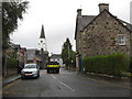
2
View of Comrie from Monument Road
Comrie Community Centre ("The White Church") in the distance.
Image: © Anthony O'Neil
Taken: 19 May 2011
0.01 miles
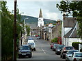
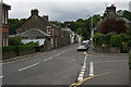
3
Dundas Street, Comrie, on a quiet Sunday morning
Image: © Gordon Brown
Taken: 5 Oct 2014
0.04 miles
4
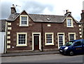
Victorian cottages in Comrie
Oval plaque shows the date 1856.
Image: © Anthony O'Neil
Taken: 19 May 2011
0.05 miles
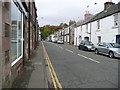
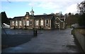
5
Dundas Street, Comrie
The main road (Dundas Street) is the A85, which runs through Comrie. The road to the right is School Road, leading to Comrie Primary School.
Image: © Richard Sutcliffe
Taken: 18 Jul 2015
0.05 miles
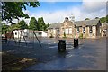
7
Primary School, Comrie
The main school building hasn't changed much since it was built in 1909. Today the school has nearly 160 pupils, and additional accommodation is provided in additional buildings in the grounds.
Image: © Richard Sutcliffe
Taken: 1 Mar 2009
0.05 miles
8
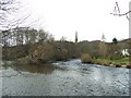
Water of Ruchill (coming from left) joining the River Earn
That is the spire of Comrie Parish Church in the background and, in the middle distance, on the left of the River Earn, is the remains of the abutment of the railway bridge.
Image: © Elliott Simpson
Taken: 23 Mar 2008
0.06 miles
9
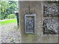
Ordnance Survey Flush Bracket S8077
This mark can be found on the wall of Comrie Parish Church.
The recorded details give a height of 61.115 metres above sea level.
For more detail see : https://www.bench-marks.org.uk/bm19083
Image: © Peter Wood
Taken: 6 Sep 2022
0.06 miles
10
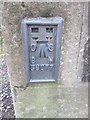
Ordnance Survey Flush Bracket (S8077)
This OS Flush Bracket can be found on the NE face of the Church. It marks a point 200.485ft above mean sea level.
Image: © Adrian Dust
Taken: 12 Apr 2016
0.06 miles