IMAGES TAKEN NEAR TO
Dunira Street, CRIEFF, PH6 2LJ
Introduction
This page details the photographs taken nearby to Dunira Street, PH6 2LJ by members of the Geograph project.
The Geograph project started in 2005 with the aim of publishing, organising and preserving representative images for every square kilometre of Great Britain, Ireland and the Isle of Man.

There are currently over 7.5m images from over14,400 individuals and you can help contribute to the project by visiting https://www.geograph.org.uk
Image Map (Loading...)


Getting Data...Please wait
Leaflet Map data © OpenStreetMap
Images are licensed for reuse under creativecommons.org/licenses/by-sa/2.0
Notes
- Clicking on the map will re-center to the selected point.
- The higher the marker number, the further away the image location is from the centre of the postcode.
Image Listing (104 Images Found)
Images are licensed for reuse under creativecommons.org/licenses/by-sa/2.0
Image
Details
Distance
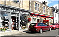
2
Dunira Street, Comrie
The white car is being unloaded outside the Comrie Cancer Club - the village's charity shop. The shop regularly raises £2,000 - £3,000 a month towards a variety of different local cancer-related charities.
Image: © Richard Sutcliffe
Taken: 18 Jul 2015
0.01 miles
3
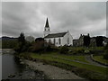
The White Church, Comrie
Originally constructed in 1805, The White Church, a Grade A listed building, is now a community centre in the conservation village of Comrie. Formerly a Church of Scotland building, the property was handed over by C of S General Trustees to the community in 1965.
Image: © Douglas Nelson
Taken: 20 Apr 2017
0.01 miles
4
The White Church, Comrie
This former church in Comrie now acts as a community centre.
Image: © Euan Nelson
Taken: 13 May 2018
0.01 miles

6

The White Church
A view of the White Church in the village of Comrie taken from the Dalginross Bridge.
Image: © Mr S Mudgey
Taken: 8 Jul 2007
0.02 miles

8
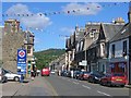
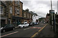
Comrie
Drummond Street, carrying the A85 through this small Perthshire town, situated on the Highland Boundary Fault.
Image: © Richard Webb
Taken: 22 Aug 2005
0.02 miles
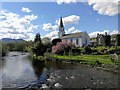
9
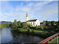
Comrie Community Centre
Comrie Community Centre, also known as the White Church, on the banks of the River Earn, viewed from Dalginross Bridge.
Image: © Scott Cormie
Taken: 2 Aug 2017
0.02 miles
10
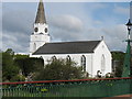
The White Church, Comrie, from Dalginross Bridge
This former church has long been used as the community centre for the village. The current church is about 300 metres away to the WNW.
Image: © David Purchase
Taken: 28 May 2010
0.02 miles