IMAGES TAKEN NEAR TO
Comrie, CRIEFF, PH6 2JQ
Introduction
This page details the photographs taken nearby to PH6 2JQ by members of the Geograph project.
The Geograph project started in 2005 with the aim of publishing, organising and preserving representative images for every square kilometre of Great Britain, Ireland and the Isle of Man.

There are currently over 7.5m images from over14,400 individuals and you can help contribute to the project by visiting https://www.geograph.org.uk
Image Map
Images are licensed for reuse under creativecommons.org/licenses/by-sa/2.0
Notes
- Clicking on the map will re-center to the selected point.
- The higher the marker number, the further away the image location is from the centre of the postcode.
Image Listing (4 Images Found)
Images are licensed for reuse under creativecommons.org/licenses/by-sa/2.0
Image
Details
Distance
1
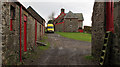
Tigh-na-Blair
The farmhouse at Tigh-na-Blair is seen here from the road reaching it from the west, as it passes between barns.
Image: © Trevor Littlewood
Taken: 28 Oct 2010
0.03 miles
2
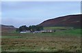
Tigh na Blair
Farm on the rarely used Ben Clach military range.
Image: © Richard Webb
Taken: 8 Oct 2006
0.05 miles
3
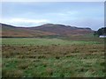
Fields, Tigh na Blair
Fields in front of the farm.
Image: © Richard Webb
Taken: 8 Oct 2006
0.11 miles
4
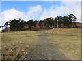
Small plantation of pines on lower slopes of Little Hill
Image: © John Ferguson
Taken: 13 Mar 2020
0.15 miles