IMAGES TAKEN NEAR TO
Comrie, CRIEFF, PH6 2JA
Introduction
This page details the photographs taken nearby to PH6 2JA by members of the Geograph project.
The Geograph project started in 2005 with the aim of publishing, organising and preserving representative images for every square kilometre of Great Britain, Ireland and the Isle of Man.

There are currently over 7.5m images from over14,400 individuals and you can help contribute to the project by visiting https://www.geograph.org.uk
Image Map
Images are licensed for reuse under creativecommons.org/licenses/by-sa/2.0
Notes
- Clicking on the map will re-center to the selected point.
- The higher the marker number, the further away the image location is from the centre of the postcode.
Image Listing (9 Images Found)
Images are licensed for reuse under creativecommons.org/licenses/by-sa/2.0
Image
Details
Distance
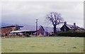
1
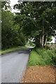
Strowan Road, near Comrie
Looking in the direction of Crieff from just outside Comrie.
Image: © Richard Sutcliffe
Taken: 19 Jul 2015
0.07 miles
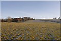
2
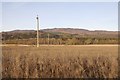
Near Fairness, Strath Earn
A view from the South Crieff Road towards Càrn Chrois
Image: © Richard Webb
Taken: 1 Dec 2019
0.08 miles
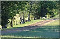
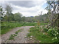
4
Track up the hill outside Comrie
This track follows the edge of a field up a slight hill from Strowan Road, just east of Comrie.
Image: © Richard Sutcliffe
Taken: 19 Jul 2015
0.17 miles
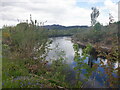
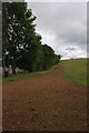
9
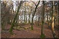
Woodland, Dalginross
Seen from the South Crieff Road.
Image: © Richard Webb
Taken: 1 Dec 2019
0.25 miles