IMAGES TAKEN NEAR TO
Muthill, CRIEFF, PH5 2DB
Introduction
This page details the photographs taken nearby to PH5 2DB by members of the Geograph project.
The Geograph project started in 2005 with the aim of publishing, organising and preserving representative images for every square kilometre of Great Britain, Ireland and the Isle of Man.

There are currently over 7.5m images from over14,400 individuals and you can help contribute to the project by visiting https://www.geograph.org.uk
Image Map
Images are licensed for reuse under creativecommons.org/licenses/by-sa/2.0
Notes
- Clicking on the map will re-center to the selected point.
- The higher the marker number, the further away the image location is from the centre of the postcode.
Image Listing (7 Images Found)
Images are licensed for reuse under creativecommons.org/licenses/by-sa/2.0
Image
Details
Distance
1
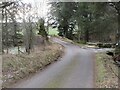
Road at the Mill of Drummond
Minor road heading south at the Mill of Drummond.
Image: © Scott Cormie
Taken: 3 Jan 2025
0.02 miles
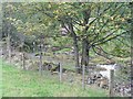
2
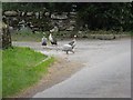
Guinea fowl on guard
A very vociferous group of birds.
Image: © M J Richardson
Taken: 5 Sep 2010
0.03 miles
3
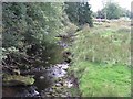
The Machany Water at Mill of Drummond
Looking upstream.
Image: © M J Richardson
Taken: 5 Sep 2010
0.03 miles
4
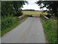
Bridge over the Machany Water
Looking south at Mill of Drummond.
Image: © M J Richardson
Taken: 5 Sep 2010
0.06 miles
5
The Machany Water
Looking downstream from the Mill of Drummond. Complete with resting Heron in midstream.
Image: © M J Richardson
Taken: 5 Sep 2010
0.07 miles
6
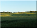
Farmland, Mill of Drummond
Arable farmland rises to pasture and low moorland.
Image: © Andrew Smith
Taken: 13 Jul 2006
0.11 miles
7
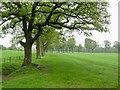
Fields, Muirhead
The Drummond area has a lot of big oak trees.
Image: © Richard Webb
Taken: 17 May 2022
0.25 miles