IMAGES TAKEN NEAR TO
Muthill, CRIEFF, PH5 2BY
Introduction
This page details the photographs taken nearby to PH5 2BY by members of the Geograph project.
The Geograph project started in 2005 with the aim of publishing, organising and preserving representative images for every square kilometre of Great Britain, Ireland and the Isle of Man.

There are currently over 7.5m images from over14,400 individuals and you can help contribute to the project by visiting https://www.geograph.org.uk
Image Map
Images are licensed for reuse under creativecommons.org/licenses/by-sa/2.0
Notes
- Clicking on the map will re-center to the selected point.
- The higher the marker number, the further away the image location is from the centre of the postcode.
Image Listing (5 Images Found)
Images are licensed for reuse under creativecommons.org/licenses/by-sa/2.0
Image
Details
Distance
3
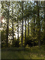
Woodland next to Machany Water
On the northern bank.
Image: © Andrew Smith
Taken: 14 Jul 2006
0.15 miles
4
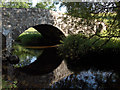
Bridge over Machany Water
The Old Military Road crosses the stream below Lurgs.
Image: © Andrew Smith
Taken: 14 Jul 2006
0.15 miles
5
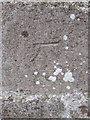
Ordnance Survey Cut Mark
This OS cut mark can be found on the roadside building at Lurg. it marks a point 117.528m above mean sea level.
Image: © Adrian Dust
Taken: 13 Apr 2016
0.25 miles