IMAGES TAKEN NEAR TO
Muthill, CRIEFF, PH5 2BP
Introduction
This page details the photographs taken nearby to PH5 2BP by members of the Geograph project.
The Geograph project started in 2005 with the aim of publishing, organising and preserving representative images for every square kilometre of Great Britain, Ireland and the Isle of Man.

There are currently over 7.5m images from over14,400 individuals and you can help contribute to the project by visiting https://www.geograph.org.uk
Image Map
Images are licensed for reuse under creativecommons.org/licenses/by-sa/2.0
Notes
- Clicking on the map will re-center to the selected point.
- The higher the marker number, the further away the image location is from the centre of the postcode.
Image Listing (3 Images Found)
Images are licensed for reuse under creativecommons.org/licenses/by-sa/2.0
Image
Details
Distance
2
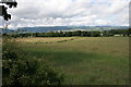
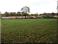
Farmland east of Muthill
Looking north from the A822 opposite Muthill Cemetery. The tree line follows a minor road (Station Road) running east from Muthill.
The new Beauly-Denny power line can be seen on the right.
Image: © Richard Sutcliffe
Taken: 19 Jul 2015
0.18 miles
3
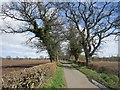
Minor road leaving Muthill
A continuation of Wardside.
Image: © Richard Webb
Taken: 24 Apr 2013
0.23 miles