IMAGES TAKEN NEAR TO
Muthill, CRIEFF, PH5 2BH
Introduction
This page details the photographs taken nearby to PH5 2BH by members of the Geograph project.
The Geograph project started in 2005 with the aim of publishing, organising and preserving representative images for every square kilometre of Great Britain, Ireland and the Isle of Man.

There are currently over 7.5m images from over14,400 individuals and you can help contribute to the project by visiting https://www.geograph.org.uk
Image Map
Images are licensed for reuse under creativecommons.org/licenses/by-sa/2.0
Notes
- Clicking on the map will re-center to the selected point.
- The higher the marker number, the further away the image location is from the centre of the postcode.
Image Listing (7 Images Found)
Images are licensed for reuse under creativecommons.org/licenses/by-sa/2.0
Image
Details
Distance
1
Parkhead Farm
Looking north towards main farm buildings
Image: © Derek Ferris
Taken: 27 Aug 2007
0.01 miles
2
NE to Parkhead Farm
For Ken, who spent some of his younger years here.
Hope it brings back many happy memories.
Image: © Derek Ferris
Taken: 27 Aug 2007
0.02 miles
3
Parkhead Farm
A distant view of Parkhead from the south-west.
Image: © Scott Cormie
Taken: 11 Oct 2020
0.03 miles
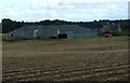
4
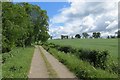
Strathearn farmland
Beside a gravel road to Colquhalzie.
Image: © Richard Webb
Taken: 21 Jun 2015
0.09 miles
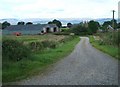
5
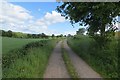
Road to Colquhalzie
An unsealed road serving Parkhead, Colqualzie and Auchinglen.
Image: © Richard Webb
Taken: 21 Jun 2015
0.13 miles
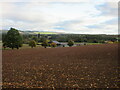
6
Road to Colquhalzie
A gravel road serving scattered dwellings in Strathearn.
Image: © Richard Webb
Taken: 21 Jun 2015
0.19 miles
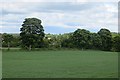
7
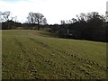
Strageath Roman Fort
Image taken of Strageath Roman Fort as it slopes down towards the River Earn.
Image: © John Chroston
Taken: 16 Feb 2015
0.21 miles