IMAGES TAKEN NEAR TO
Muthill, CRIEFF, PH5 2BG
Introduction
This page details the photographs taken nearby to PH5 2BG by members of the Geograph project.
The Geograph project started in 2005 with the aim of publishing, organising and preserving representative images for every square kilometre of Great Britain, Ireland and the Isle of Man.

There are currently over 7.5m images from over14,400 individuals and you can help contribute to the project by visiting https://www.geograph.org.uk
Image Map
Images are licensed for reuse under creativecommons.org/licenses/by-sa/2.0
Notes
- Clicking on the map will re-center to the selected point.
- The higher the marker number, the further away the image location is from the centre of the postcode.
Image Listing (9 Images Found)
Images are licensed for reuse under creativecommons.org/licenses/by-sa/2.0
Image
Details
Distance
1
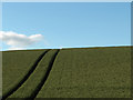
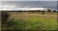
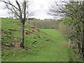
Farmland, Ladyston
The field immediately east of Ladyston - the slope of Kirk Hill.
Image: © Andrew Smith
Taken: 9 Jul 2006
0.08 miles
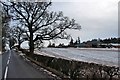
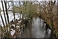
2
Machany Water
Looking downstream from near a road bridge.
Image: © Richard Webb
Taken: 16 May 2013
0.12 miles
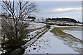
4
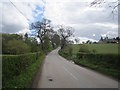
Drumness
A minor road climbs from a bridge over the Machany Water.
Image: © Richard Webb
Taken: 16 May 2013
0.16 miles
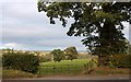
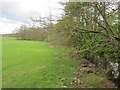
5
Field, Drumness
Beside the Machany Water.
Image: © Richard Webb
Taken: 16 May 2013
0.16 miles