IMAGES TAKEN NEAR TO
Kinlochleven Business Park, KINLOCHLEVEN, PH50 4SH
Introduction
This page details the photographs taken nearby to Kinlochleven Business Park, PH50 4SH by members of the Geograph project.
The Geograph project started in 2005 with the aim of publishing, organising and preserving representative images for every square kilometre of Great Britain, Ireland and the Isle of Man.

There are currently over 7.5m images from over14,400 individuals and you can help contribute to the project by visiting https://www.geograph.org.uk
Image Map
Images are licensed for reuse under creativecommons.org/licenses/by-sa/2.0
Notes
- Clicking on the map will re-center to the selected point.
- The higher the marker number, the further away the image location is from the centre of the postcode.
Image Listing (146 Images Found)
Images are licensed for reuse under creativecommons.org/licenses/by-sa/2.0
Image
Details
Distance
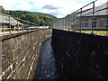
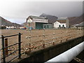
2
Tailrace channel, Kinlochleven
Spent water from the hydro power station en route to join the River Leven.
Image: © Jim Barton
Taken: 20 Nov 2015
0.01 miles
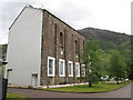
4
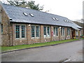
Blackwater Hostel Kinlochleven
First class accommodation.
Image: © John Ferguson
Taken: 28 Mar 2010
0.03 miles
5
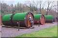
Camping pods at Blackwater Hostel, Kinlochleven
Part of the range of self-catering accommodation at the hostel and campsite here.
Image: © Jim Barton
Taken: 20 Nov 2015
0.03 miles
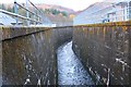
6
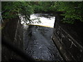
Rush of water at Kinlochleven
This photo does not convey the fact that the water in the channel below rushes by very quickly before entering the river beyond.
Image: © Peter S
Taken: 4 Jun 2014
0.03 miles
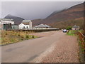
7
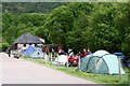
Camp site on the banks of the river Leven
Image: © Des Colhoun
Taken: 3 Jun 2012
0.03 miles
9
Blackwater Hostel
Independent hostel beside the River Leven, Kinlochleven.
The red symbol on the OS Map puts the building in two squares - it is actually in NN1862 according to my smartphone Grid Ref app. The red square being much larger than the actual building.
Image: © Chris Heaton
Taken: 9 May 2016
0.04 miles
10
Ice Factor and Atlas Brewery from the rear
Image: © Peter Bond
Taken: 24 Jan 2004
0.04 miles