IMAGES TAKEN NEAR TO
Laroch Beag, BALLACHULISH, PH49 4LB
Introduction
This page details the photographs taken nearby to Laroch Beag, PH49 4LB by members of the Geograph project.
The Geograph project started in 2005 with the aim of publishing, organising and preserving representative images for every square kilometre of Great Britain, Ireland and the Isle of Man.

There are currently over 7.5m images from over14,400 individuals and you can help contribute to the project by visiting https://www.geograph.org.uk
Image Map
Images are licensed for reuse under creativecommons.org/licenses/by-sa/2.0
Notes
- Clicking on the map will re-center to the selected point.
- The higher the marker number, the further away the image location is from the centre of the postcode.
Image Listing (48 Images Found)
Images are licensed for reuse under creativecommons.org/licenses/by-sa/2.0
Image
Details
Distance
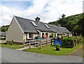
1
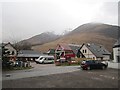
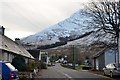
Care home, Ballachulish
A damp morning with Sgorr Bhan just visible in the background.
Image: © Richard Webb
Taken: 16 Feb 2013
0.05 miles
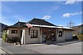
3
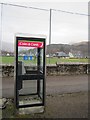
Telephone box, Ballachulish
A Monster sticker brightens up the old "prancing pervert" BT logo.
Image: © Richard Webb
Taken: 16 Feb 2013
0.08 miles
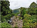
4
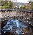
Bridge over the River Laroch, Ballachulish
Image: © Donald MacDonald
Taken: 14 Nov 2010
0.08 miles
5
Loanfern, Ballachulish
The road to the bridge over the River Laroch with the NE ridge of Sgorr Bhan high above.
Image: © Jim Barton
Taken: 18 Nov 2016
0.09 miles
6
Ballachulish looking south west
The hills in the background are Beinn Bhan to the right and the Munro Sgorr Dearg, part of the Beinn a' Bheithir horseshoe, to the left. Many thanks to Malcolm Rooney, who grew up in the area on the 1950's for bringing this information to my attention.
Image: © Frank Garvock
Taken: 23 Mar 2008
0.11 miles
7
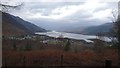
Ballachulish Village
Looking towards the NWW with Ballachulish Village, Loch Leven and the Ballachulish bridge in the far distant.
Image: © Cyril
Taken: 7 Dec 2015
0.12 miles
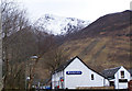
8
Ballachulish Medical Centre
Originally Ballachulish Station; it was the terminus of a branch from the Callander to Oban line, running from Connel Ferry. It opened in 1903 and closed in 1966.
Image: © Robert Struthers
Taken: 1 Apr 2018
0.12 miles
10

Ballachulish
West Laroch, Ballachulish. Road to old slate quarry.
For an identical view in around 1912, from a Valentine's postcard, see http://postcards.pikfu.net/set1951375/media69409499.html The road leads to the former slate quarry and quarriers' cottages are prominent in the old photograph.
Image: © Douglas Nelson
Taken: 10 May 1999
0.13 miles