IMAGES TAKEN NEAR TO
Tigh A' Phuirt, BALLACHULISH, PH49 4HN
Introduction
This page details the photographs taken nearby to PH49 4HN by members of the Geograph project.
The Geograph project started in 2005 with the aim of publishing, organising and preserving representative images for every square kilometre of Great Britain, Ireland and the Isle of Man.

There are currently over 7.5m images from over14,400 individuals and you can help contribute to the project by visiting https://www.geograph.org.uk
Image Map (Loading...)


Getting Data...Please wait
Leaflet Map data © OpenStreetMap
Images are licensed for reuse under creativecommons.org/licenses/by-sa/2.0
Notes
- Clicking on the map will re-center to the selected point.
- The higher the marker number, the further away the image location is from the centre of the postcode.
Image Listing (58 Images Found)
Images are licensed for reuse under creativecommons.org/licenses/by-sa/2.0
Image
Details
Distance
6
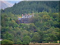
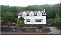
Scaffolding on Glencoe House
Glencoe House was used as a hospital during WW2 then became a geriatric hospital, closing in 2008. It has now been bought by a local businessman.
Image: © Dave Fergusson
Taken: 4 Sep 2011
0.04 miles
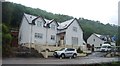
9
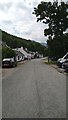
Clennoch, Glencoe
Just off the A82.
Image: © Richard Sutcliffe
Taken: 4 Sep 2016
0.05 miles
